


Thar Desert is a rainfall deficient (∼500-100mm/year) region in the northwestern India. Previously published information on sediment facies, mineralogy, and radiocarbon chronology helped to reconstruct orbital-scale lake stands and variations in water column salinity of five different lacustrine basins in the desert. We evaluated the hydrological conditions with respect to strength (i.e., amount and geographic coverage) of the southwest summer monsoon since the last glacial maximum (LGM). Between LGM and c.15cal. ka BP, the eastern basins hosted saline and hypersaline playa lakes and the western part had an intermittent variable lake. A shift from saline-hypersaline playa lakes to perennial deep lakes occurred in the eastern margin at c.15cal. ka BP as more summer insolation increased sea surface temperature (SST) of the Indian Ocean and strengthened the southwest summer monsoon. During the Pleistocene-Holocene transition, the highest summer insolation as well as warmer SST of the Indian Ocean increased the amount of summer precipitation and expanded the southwest monsoon over the entire desert. However, more winter precipitation and minimal summer rainfall maintained perennial lakes across the desert during the early and middle Holocene. Over the middle-late Holocene, the regional arid conditions were contemporary to intervals of reduced summer insolation, southerly located Inter-Tropical Convergence Zone and frequent El-Niño Southern Oscillation.
El desierto de Thar está ubicado en la parte noroccidental de la India y es una región con escasez de lluvia (∼500-100mm/año). Los datos previamente publicados sobre la mineralogía, facies sedimentarias y cronología de radiocarbono han ayudado a reconstruir los cambios en el nivel lacustre y la salinidad de los cuerpos de agua en la escala orbital en cinco diferentes cuencas lacustres del desierto. Se evaluaron las condiciones hidrológicas en términos de la variación en la fuerza (cantidad y cobertura geográfica) del monzón del suroeste desde el último máximo glacial (UMG). Entre el UMG y aproximadamente 15 ka cal AP, las cuencas de la parte oriental mantuvieron lagos salinos e hipersalinos y la parte occidental tuvo un lago intermitente. El cambio de una playa salina-hipersalina a un lago perenne con condiciones profundas ocurrió en la margen oriental alrededor de los 15 ka cal AP a medida que la insolación de verano aumentó tanto la temperatura superficial del mar (TSM) del Océano Índico como la fuerza del monzón del suroeste. Durante la transición del Pleistoceno al Holoceno, la mayor insolación de verano y la alta TSM del Océano Índico aumentaron la cantidad de lluvia de verano y facilitaron la expansión del monzón a todo el desierto. Sin embargo, el predominio de las precipitaciones de invierno sobre las lluvias de verano durante el Holoceno temprano y medio mantuvieron lagos perennes a lo largo del desierto. Durante el Holoceno medio y tardío, las condiciones más secas en la región fueron contemporáneas a los intervalos de reducción en la insolación de verano, la ubicación de la Zona de Convergencia Intertropical en una latitud sureña y el aumento en la actividad de El Niño-Oscilación del Sur.
The southwest summer monsoon is one of the principal global meteorological systems and it contributes dominantly to hydrological budget of India1. It begins from southern margins of the country in the earliest stage and reaches the northwestern part at an advanced stage (Figure 1). Modelling studies suggest a strong link between strength of the monsoon system and summer insolation2,3. Insolation modulated sea surface temperature (SST) of the tropical Indian Ocean and associated evaporation provide most of the water vapour for precipitation4,5. More summer precipitation is related to warmer conditions in the Arabian Sea during the pre-monsoon months6 and position of the Inter-Tropical Convergence Zone (ITCZ) at northern latitudes7,8. SST anomalies in the central-eastern Pacific Ocean associated with the El Niño-Southern Oscillation (ENSO) also have a teleconnection with the monsoon9,10. Below normal summer rainfall occurs during the El Niño years and the rainfall is above average in years with La Niña conditions11,12. Recently, Annamalai et al. (2013)13 observed that amounts of modern era rainfall shows inverse relationship with concentrations of greenhouse gases in the atmosphere and SST of the western Pacific Ocean.
 of the Indian Ocean.")
A large part of the Thar Desert is located in western part of the Rajasthan state of India. Reviewed lacustrine basins are present in an east-west transect. Terrigenous input into the eastern Arabian Sea17 estimates summer precipitation associated with the southwest monsoon and alkenones from the western Arabian Sea18 provide information about sea surface temperature (SST) of the Indian Ocean.
In geological registers, varying strengths of the summer monsoon was in phase with North Hemisphere insolation14. This relationship weakened with increasing influence of the glacial forcing. Influence of ITCZ on the Indian monsoon was evaluated in speleothem records from the Oman and Yemen for the Holocene15 and in sediments of the Arabian Sea for the late Pleistocene16. Productivity of planktic foraminifera and terrigenous input into the Arabian Sea suggest that the Indian monsoon responded to variations in the Northern Hemisphere temperature16,19. Monsoon was weaker during the cooler intervals/events.
The Thar Desert is located in northwestern India and a large part of it is present in western part of the Rajasthan state (Figure 1). This hydrologically deficient region hosts numerous topographically closed and centripetally fed ephemeral lacustrine basins. Presence of alluvium and fluvially reworked aeolian sand below the lacustrine deposits suggests riverine ancestry for most of the basins20–25. Transition from fluvial to lacustrine regime in some of the basins occurred as a result of segmentation of river channels by excessive siltation during intervals of less runoff and formation of sand barriers during intervals of enhanced aeolian activity26–29. Longitudinal dunes also guided some of the ephemeral streams to feed inter-dunal basins30. Similarly, tectonic activity31,32 might have disorganised some of the paleo-streams and formed lacustrine basins.
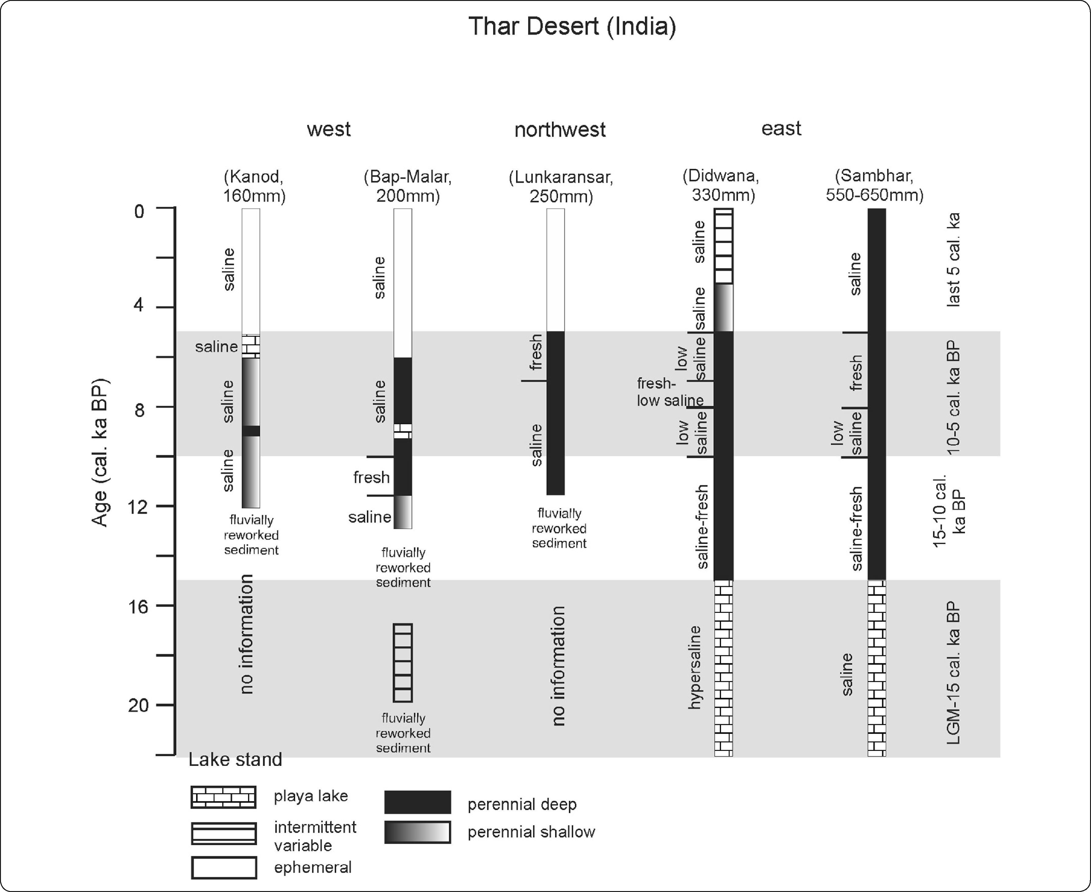
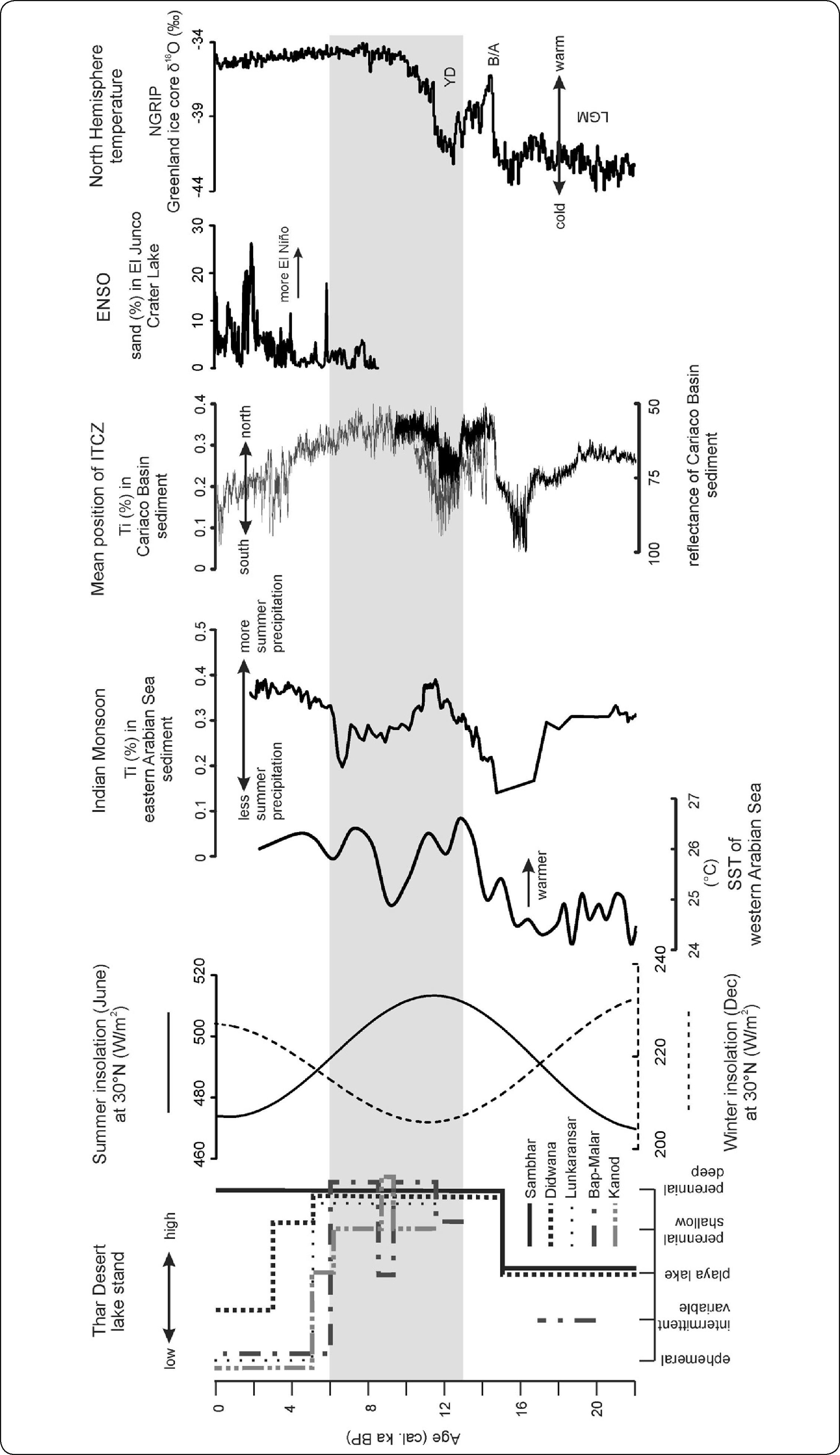
Stratigraphy, mineralogy, and geochemistry of lacustrine deposits as well as fossil pollen were used for reconstruction of hydrological variations occurred over the late Pleistocene and Holocene20,21,25,33–40. In this study, we reconstruct hydrological conditions (lake stands and salinity) in orbital time scales from the synthesis of published information on sediment facies and mineralogy of 5 different lacustrine basins (i.e., Sambhar, Didwana, Lunkaransar, Bap-Malar and Kanod) from the Thar Desert. Varying lake stands and lake water salinities are reconstructed for four different intervals, i.e., Last Glacial Maximum (LGM)-c.15cal. ka BP (cal. ka BP=thousands of calendar years before AD 1950), c.15-10cal. ka BP, c.10-5cal. ka BP and last c.5cal. ka. We evaluated the paleohydrological changes with respect to amounts of the summer precipitation estimated from terrigenous input into the eastern Arabian Sea16 and SST of the Indian Ocean18. Influences of insolation, North Hemisphere temperature, mean position of ITCZ and frequency and magnitude of ENSO on strength and geographic coverage of the southwest monsoon are identified by comparing the reconstructed hydrological conditions with summer and winter insolations at 30°N latitude41, oxygen isotope composition of the Greenland ice core (NGRIP project members 2004), reflectance and Ti concentration in sediments from the Cariaco Basin16,42 and sand content in sediments of the El Junco Crater Lake from the Galapagos Islands43.
MODERN CLIMATEThe Thar Desert of India receives ∼80% of its annual precipitation from the southwest summer monsoon and the eastward migration of mid-latitude winter cyclones (originating over the west Asia and Mediterranean) contributes < 20% of the annual rainfall29,39. Eastern margin of the desert receives an average annual precipitation of ∼600mm and the western margin receives ≤100mm. The low and variable rainfall in the region is related to lack of atmospheric moisture condensation44–46. Instrumental records of AD 1901-2010 indicate that annual precipitations of the Thar Desert is positively correlated (r=0.6, p<0.05) with the southwest Indian monsoon. The negative correlation between annual precipitation of the western Rajasthan and El Niño 3.4 index (r=-0.3, p<0.05) suggests that the amount of summer precipitation decreased during the El Niño years. In this region, the maximum temperature reaches up to 45-50°C during summer months and the minimum temperature remains at 3-10°C during winter months (source: Indian Institute of Tropical Meteorology, Pune). Annual evapo-transpiration is ∼1500mm in the eastern margin and more than ∼2500mm in the western margin.
LACUSTRINE BASINSLacustrine basins synthesized in this paper are located in different present day precipitation regimes and have different physical and chemical attributes (Figure 1 and Table I). Both the Sambhar (∼550-650mm/year) and Didwana (∼330mm) basins are present in eastern part of the desert. The Lunkaransar basin is located in northwestern part and receives ∼250mm of annual precipitation. The Bap-Malar (∼200mm/year) and Kanod (∼160mm/year) basins are present in western part of the desert.
Comparative physical and chemical parameters of the reviewed lacustrine basins of the Thar Desert, India.
| Basins | Kanod | Bap-Malar | Lunkaransar | Didwana | Sambhar |
|---|---|---|---|---|---|
| Location | 27° 08’ N71° 14’ E | 27° 18’ N72° 24’ E | 28° 30’ N73° 45’ E | 27° 20’ N74° 35’ E | 27° 70’ N75° 00’ E |
| Area (in sq. km) | 32 | 78 | 5 | ∼12 | ∼225 |
| Orientation | NE-SW | N-S | NE-SW | NE-SW | ENE-WSW |
| Rainfall (mm/year) | 160 | 200 | ∼250 | 330 | ∼550-650 |
| Evapo-transpiration (mm/year) | >2500 | >2500 | >2500 | ∼1650 | ∼1500 |
| Corg (%) | 1.3% | ∼0.6% | - | ∼0.5% | ∼3% |
| Pollen | Cyperaceae, Gramineae,Typhaceae,Pinaceae, Chenopodiaceae | Cyperaceae, Gramineae, Typhaceae, Compositae, Ephedraceae | Typha angustata, Syzygium cumini, Oldenlandia, Mimosa rubicaulis | Typha angustata, Syzygium cumini, Oldenlandia, Mimosa rubicaulis | Typha angustata, Syzygium cumini, Oldenlandia, Mimosa rubicaulis |
| δ13Corg (‰) | -15 to -16 | -15 to -18 | -11 to -25 | - | - |
| Clastic mineral | Qtz, Felds, M, hematite | Qtz, Pl, Kf, M, Chl, Amp, hematite | Qtz, Pl, Kf, M, Chl, illite-smectite, Amp | Qtz, Pl, Kf, M, Chl, Amp, kaolinite, illite-smectite, Ca-Na-zeolite | Qtz, Pl, Kf, M, Chl, Amp, kaolinite, goethite, illite-smectite, Na-zeolite |
| Evaporite mineral | Cc, Arg, Gyp, Hal | Cc, Dol, Gyp, Anh, Hal | Cc, Gyp, Hal | Cc, Dol, Tr, Northup, Mag, Gyp, Thenar, Anh, Hal | Cc, Dol, Arg, Tr, Gyp, Anh, Thenar, Mirab, Kieser, Glaub, Bloed, Polyh, Hal, Carnal, Syl |
| Catchment geology | sandstone, limestone, conglomerate | sand dune, sandstone, limestone, boulder bed | sand dune, limestone, shale, sandstone, bentonites | sand dune, quartzite, slate | sand dune, quartzite, mica-schist, gneiss, amphibolite |
| Basement rock | silt stone | sandstone | - | granite | mica schist |
| Antiquity (cal. ka BP) | >11 | ∼20 | - | >20 | >30 |
| Origin | channel segmentation | neotectonics | neotectonic | neotectonic | neotectonic |
Qtz: quartz; Felds: feldspars; Pl: plagioclases; Kf: K-feldspars; M: micas; Chl: chlorite; Amp: amphiboles; Cc: calcite CaCO3; Dol: dolomite CaMg(CO3)2; Hunt: huntite CaMg3(CO3)4; Arg: aragonite CaCO3; Mag: magnesite MgCO3; Tr: trona Na3H(CO3)2.2H2O; Northup: northupite Na3Mg(CO3)2Cl; Gyp: gypsum CaSO4.2H2O; Anh: anhydrite CaSO4; Thenar: thenardite Na2SO4; Mirab: mirabilite Na2SO4.10H2O; Kieser: kieserite MgSO4.H2O; Glau: glauberite Na2Ca(SO4)2; Bloed: bloedite Na2Mg(SO4)2.4H2O; Polyh: polyhalite K2MgCa2(SO4)4.2H2O; Hal: halite NaCl; Carnal: carnallite KMgCl3.6H2O; Syl: sylvite KCl.
Chronological information of the sedimentary deposits comes from previously published radiocarbon (conventional and AMS) dates on bulk organic sediment and pollen extracts20,21,25,35,40. Radiocarbon ages are calibrated using intcal13 curve and Calib 7.0 software47 and presented as cal. ka BP. Sediment facies with distinct mineralogical characteristics are assigned chronological information by linear interpolation between two consecutive calibrated ages and extrapolation beyond the available radiocarbon chronology.
GEOLOGYWatershed of the eastern basins (Sambhar and Didwana) consists of stable sand ridges, and quartzite, mica schist, gneiss, amphibolite and granite. Catchment of the northwestern and western basins (Lunkaransar, Bap-Malar and Kanod) comprises sandstone, conglomerate, shale, rhyolite, basalt, boulder bed and sand dune21–23,25,35,36,48. Microscopic fragments of different rocks exposed in eastern margin of the desert are present in sub-surface sediments of the western basins49. It indicates that the entire region was either fed by rivers flowing from the east or sediments of the western basins were mobilised from alluviums of the eastern rivers by aeolian processes.
SEDIMENT FACIESThe synthesis of sedimentological information is represented by 5 different facies: (i) massive sand, (ii) intercalation of sand and silt/clay, (ii) sandy-silt, (iii) weakly laminated silt/clay, and (iv) well laminated silt/clay (Figure 2). Gypsum crystals are present in different intervals of sandy-silt and silt/clay. A thick deposit of halite comprises the lower part of sediment sequence from Didwana. The facies are presented in intervals of LGM-c.15cal. ka BP, c.15-10cal. ka BP, c.10-5cal. ka BP and last c.5cal. ka.
2; Arg: aragonite CaCO3; Mag: magnesite MgCO3; Tr: trona Na3H(CO3)2.2H2O; Northup: northupite Na3Mg(CO3)2Cl; Gyp: gypsum CaSO4.2H2O; Anh: anhydrite CaSO4; Thenar: thenardite Na2SO4; Mirab: mirabilite Na2SO4.10H2O; Kieser: kieserite MgSO4.H2O; Glau: glauberite Na2Ca(SO4)2; Bloed: bloedite Na2Mg(SO4)2.4H2O; Polyh: polyhalite K2MgCa2(SO4)4.2H2O; Hal: halite NaCl; Carnal: carnallite KMgCl3.6H2O; Syl: sylvite KCl.")
Temporal distributions of sediment facies and sub-surface evaporite mineral assemblages in 5 different lacustrine basins of the Thar Desert since the Last Glacial Maximum. Minerals in bold letters are present in higher abundance and italics are present in trace amounts. Cc: calcite CaCO3; Dol: dolomite CaMg(CO3)2; Arg: aragonite CaCO3; Mag: magnesite MgCO3; Tr: trona Na3H(CO3)2.2H2O; Northup: northupite Na3Mg(CO3)2Cl; Gyp: gypsum CaSO4.2H2O; Anh: anhydrite CaSO4; Thenar: thenardite Na2SO4; Mirab: mirabilite Na2SO4.10H2O; Kieser: kieserite MgSO4.H2O; Glau: glauberite Na2Ca(SO4)2; Bloed: bloedite Na2Mg(SO4)2.4H2O; Polyh: polyhalite K2MgCa2(SO4)4.2H2O; Hal: halite NaCl; Carnal: carnallite KMgCl3.6H2O; Syl: sylvite KCl.
LGM-c.15cal. ka BP: Sediments of this interval are studied from Sambhar, Didwana and Bap-Malar basins. Abundant gypsum and minor sandy-silt represent the Sambhar sediments and abundant halite and minor silt represent sediments deposited in the Didwana. Bap-Malar sediments are characterized by intercalations of sand and gypsum bearing weakly laminated silt.
c.15-10cal. ka BP: Well laminated silt/clay represents sediments of the Sambhar and Didwana basins. The Lunkaransar basin has massive sand up to c.11.5cal. ka BP and gypsum bearing well laminated silt/clay during c.11.5-10cal. ka BP. The Bap-Malar basin has massive sand (c.15-13cal. ka BP), gypsum bearing weakly laminated silt (c.13-11cal. ka BP) and well laminated silt (c.11-10cal. ka BP). The Kanod basin has massive sand till c.11.5cal. ka BP and gypsum bearing weakly laminated silt during c.11.5-10cal. ka BP.
c.10-5cal. ka BP: Sediments from both the Sambhar and Didwana basins are well laminated silt/clay. In the Lunkaransar basin, sediments also comprise well laminated silt/clay. The Bap–Malar sediments are well laminated silt (c.10-6cal. ka BP) and sandy silt (c.6-5cal. ka BP). Abundant gypsum represents the sediments of c.9cal. ka BP. In general, sediments of the Kanod are weakly laminated silt. Laminated silt was deposited at c.9cal. ka BP and abundant gypsum and minor sandy-silt were deposited at c.6-5cal. ka BP.
Last c.5cal. ka: Sambhar sediments are well laminated silt/clay. Didwana basin has weakly laminated silt/clay (c.5-3cal. ka BP) and intercalations of sand and silt (last c.3cal. ka BP). Sandy-silt represents sediments of the Lunkaransar, Bap-Malar and Kanod basins.
MINERALOGYClastic mineralClastic mineral assemblage is similar and consists of quartz, feldspar, mica and chlorite. Quartz is the most abundant clastic mineral and it is followed by plagioclase. K-feldspar, mica, chlorite and amphibole are present in traces (Table I). Additionally, kaolinite, smectite and different zeolites occur in the Sambhar and Didwana basins21,37. The Lunkaransar sediments contain traces of illite-smectite35 and sediments from the Bap-Malar and Kanod basins contain hematite25.
Evaporite mineralEvaporite minerals (Table I) vary significantly21,25,35–37,50. Calcite, halite and gypsum are major authigenic minerals. Dolomite, huntite, trona, northupite, thenardite, anhydrite, polyhalite, kieserite, mirabilite, bloedite, carnallite and sylvite occur in different abundances. Dolomite is a major constituent in sediments of the Sambhar and Didwana basins and present in trace amounts in the Bap-Malar basin. It is not reported in the Lunkaransar and Kanod basins. Thermal characteristic suggests that dolomite is Fe-bearing and non-stoichiometric38,51,52. Except for the thick sequences of halite deposited during LGM-c.15cal. ka BP in the Didwana basin, all the other basins have halite as sub-surface precipitate. Similar to sediment facies, the evaporite mineral assemblages are presented in the four different intervals (Figure 2).
LGM-c.15cal. ka BP: Gypsum is abundant and calcite, dolomite, thenardite, mirabilite, anhydrite, polyhalite, bloedite and sylvite are present as minor constituents in the Sambhar basin. In the Didwana basin, halite is abundant and calcite and dolomite occur in minor amounts. The Bap-Malar sediments have minor amounts of calcite and traces of gypsum.
c.15-10cal. ka BP: The Sambhar sediments contain varying abundances of gypsum, halite, calcite, dolomite, thernardite, glauberite, kieserite, bloedite. Gypsum and halite are more in sediments of c.15-13cal. ka BP and dolomite is more in sediments deposited between c.13 and 10cal. ka BP. Similarly, the Didwana sediments have more calcite and dolomite and traces of gypsum. The Lunkaransar, Bap-Malar and Kanod basins have more calcite and traces of gypsum.
c.10-5cal. ka BP: Abundances of dolomite, calcite and halite are more compared to polyhalite, bloedite and aragonite in Sambhar. Dolomite and halite are present in sediments of c.10-8cal. ka BP, whereas calcite, dolomite and halite occur in sediments of c.8-5cal. ka BP. The Didwana sediments have more calcite and dolomite during c.10-8cal. ka BP and c.7-5cal. ka BP. Magnesite, northupite and dolomite occur between c.8 and 7cal. ka BP. Gypsum is absent in sediments of both the Sambhar and Didwana basins. In the Lunkaransar basin, trace amounts of gypsum is present during c.10-9.5cal. ka BP and abundance of gypsum increases during c.9.5-7cal. ka BP. Sediments deposited during c.7-5cal. ka BP lack gypsum and calcite is present in sediments representing c.10-6cal. ka BP. Bap-Malar has a gypsum enriched horizon (∼12cm long crystal) at c.9cal ka BP. Abundance of gypsum decreases and halite and calcite are present as major constituent during c.9-6cal. ka BP. Sediments of Kanod have more halite and calcite and traces of gypsum during c.9-5.5cal. ka BP. A gypsum enriched layer (∼10-20cm long crystal) is deposited at c.6-5cal. ka BP.
Last c.5cal. ka: Sediments of Sambhar lack gypsum and the sulphate assemblage consists of traces of thenardite, mirabilite, kieserite, glauberite and polyhalite. Similarly, traces of thenardite and anhydrite comprise the sulphate assemblage of Didwana. In both the basins, calcite, dolomite and halite occur in sediments deposited over the last c.5cal. ka. There is no record of evaporite mineralogy from Lunkaransar. Bap-Malar has more halite and calcite and traces of gypsum. Sediments of Kanod have more halite and traces of gypsum.
DISCUSSIONSpatio-temporal hydrological reconstructionDifferent assemblages of clay mineral, zeolite and evaporite mineral suggest that eastern part of the desert in general received more precipitation and remained relatively humid compared to the northwestern and western parts over the last c.22cal. ka (LGM-modern era). In absence of any basaltic outcrop in the eastern part, occurrence of smectite and kaolinite in sediments of the Sambhar and Didwana basins indicated varying sediment-water interactions. Smectite has a three layer structure and represent intervals of weak leaching53,54. However, the two layer kaolinite forms in intervals of higher chemical weathering36,55,56. Absence of kaolinite in the Bap-Malar and Kanod basins implies less sediment-water interaction in the western part. Similarly, mixed layer illite-smectite in sediments of the Lunkaransar basin and its absence in sediments of the Bap-Malar and Kanod basins indicate relatively higher chemical weathering in northwestern part of the desert compared to the western part. Different sediment-water interaction in different parts of the Thar Desert is also supported by the occurrence of zeolites only in sediment of the eastern basins. Wairakite and analcime suggested prolonged interaction between alumino-silicates and brine in the Sambhar and Didwana basins21,37. However, availability of water was relatively more in the Sambhar basin compared to the Didwana basin. It is supported by presence of H2O-bearing evaporites (i.e., carnallite, polyhalite, mirabilite, bloedite and kieserite) only in sediments of the Sambhar basin.
The reconstruction of orbital-scale changes in lake stand and water column salinity of each basin is based on stratigraphic variations in sediment facies and abundance/assemblage of evaporite minerals (Figure 3). Based on the modern analogue, we used the sediment facies as a proxy of different lake stands. Presently, the Sambhar basin receives ∼550-650mm of annual precipitation and carries water even during the peak summer months. Didwana receives ∼330mm rainfall and hosts an intermittent shallow lake for a large part of the year. The Lunkaransar, Bap-Malar and Kanod basins receive ≤250mm of precipitation and are ephemeral. Different inflows and lake stands in different basins are represented by distinct sedimentological characteristics of surface sediments. Perennial lake stand at Sambhar is represented by organic rich clay and ephemeral conditions in the northwestern and western basins are represented by deposition of sandy-silt. Similarly, the intercalations of sand and silt/clay represent an intermittent and variable lake at Didwana. Based on the texture of silt/clay dominated sediment facie, we relate perennial shallow lake conditions to deposition of weakly laminated silt/clay and associate perennial deep lake conditions with presence of well laminated silt/clay. Intervals with deposition of dominant evaporite minerals and less clastics represent playa lake conditions. Singh et al. (1972)20, Wasson et al. (1984)21, Rai (1990)22, Sundaram and Pareek (1995)23, Kajale and Deotare (1997)24 and Deotare et al. (2004)25 have related the massive sand deposits below the lacustrine sediments to riverine ancestry of the basins. However, we associate the massive sand facie to absence of any lacustrine body in these basins. Sand was transported from vicinity into the basins during the intervals of minimal inflow and arid conditions.

Information on water column salinity is inferred from abundances of carbonate and sulphate and chloride minerals. Geology of the basin catchments suggests that the alkaline earth carbonates (i.e., calcite and low Mg-calcite) are authigenic and they were precipitated by degassing of CO2 during initial stages of evaporation57,58. Sediment with abundant calcite is related to intervals of a fresh water column in the basin. An increase in Mg/Ca ratio in the brine leads to precipitation of (proto)-dolomite from a low saline water column. With continued evaporation, gypsum precipitates and subsequently halite crystallises59,60. Precipitation of gypsum occurs at lower salinity (40-100g/l) compared to halite (200-300g/l)61. We associate the gypsum dominant sediment with presence of saline water column and halite dominated sediment to hypersaline water column. The subsurface precipitation of halite is secondary and occurs in sediment pores as a product of post depositional diagenesis. Except for the sediments of >15cal. ka BP in the Didwana basin, halite is present as subsurface precipitate and we did not consider it for reconstruction of the lake water salinity.
LGM-c.15cal. ka BP: Both the Sambhar and Didwana experienced playa lake conditions. Abundant gypsum in the Sambhar basin suggested presence of a saline water column and halite dominated sediments of Didwana represented a hypersaline water column. Presence of coarser sandy-silt in Sambhar and finer silt in Didwana suggest that the Sambhar basin received relatively more inflow compared to the Didwana basin. An intermittent and variable lake was present in the Bap-Malar basin. The weakly laminated clay with gypsum represented presence of a perennial shallow lake with saline water column. Similarly, the intervals with absence of any lake in the basins were associated with deposition of massive sand. A saline playa lake in Sambhar and an intermittent and variable lake in Bap-Malar suggest that the eastern part of the desert received more inflow compared to the west.
c.15-10cal. ka BP: Well laminated silt/clay suggests presence of perennial deep lakes in the Sambhar and Didwana basins. In general, both of them hosted fresh water bodies and intervals of saline water were represented by precipitation of gypsum. The northwestern and western basins lacked presence of any water body during the earlier part of this interval and hosted perennial lakes during the later part. Lunkaransar hosted a perennial deep and saline lake during c.11.5-10cal. ka BP. The Bap-Malar basin had a perennial shallow and saline lake during c.13-11.5cal. ka BP and a perennial deep fresh water lake during c.11.5-10cal. ka BP. Similarly, the Kanod basin hosted a perennial shallow and saline lake during c.11.5-10cal. ka BP.
c.10-5cal. ka BP: All the basins hosted perennial water bodies over a large part of this interval. Perennial deep lake stands continued in the Sambhar and Didwana basins. Precipitation of Fe-bearing proto-dolomite during c.10-8cal. ka BP indicated presence of low saline water body and more calcite during c.8-5cal. ka BP represented relatively fresh water body in Sambhar. During c.10-8cal. ka BP and c.7-5cal. ka BP, the deposition of proto-dolomite suggested presence of low saline water column in the Didwana basin. However, the occurrence of northupite, magnesite and dolomite indicated mixing of fresh water and low saline brine during c.8-7cal. ka BP. The Lunkaransar basin hosted perennial deep and saline lake during c.10-7cal. ka BP and perennial deep fresh water lake during c.7-5cal. ka BP. The perennial lake stands were of lesser duration in western basins. Except for the playa lake conditions at c.9cal. ka BP, Bap-Malar hosted perennial deep and saline lake between c.10 and 6cal. ka BP. A perennial shallow and saline lake was present in the Kanod basin between c.10-6cal. ka BP. A brief interval of perennial deep saline lake stand occurred at c.9cal. ka BP and the basin hosted a playa lake at c.6-5cal. ka BP.
Last c.5cal. ka: A shift from perennial fresh water lake to perennial saline lake occurred in the Sambhar basin at c.5cal. ka BP. Didwana hosted a perennial shallow and saline lake during c.5-3cal. ka BP and an intermittent and variable lake over the last c.3cal. ka. Absence of gypsum in both the eastern basins might be due to SO4 removal by precipitation of mirabilite (Na2SO4. 10H2O) and its dehydration product thenardite (Na2SO4) during the winter months. Eardley (1962)62 observed that mirabilite precipitation occurred during the winter months (4-6°C) in the Great Salt Lake of Utah. Similarly, the glauberite and bloedite are authigenic minerals and form at the expense of earlier precipitated gypsum, mirabilite and kieserite by reaction with Na-rich brine36,63. Presence of most of these evaporites in the Sambhar basin can be attributed to dissolution and re-precipitation of earlier deposited sulphate minerals in Na-rich saline brine. In the northwestern and western parts, deposition of sandy-silt represented ephemeral conditions at Lunkaransar, Bap-Malar and Kanod.
ForcingThe reconstructed lake stands and salinity of water columns indicate that hydrological variability in the Thar Desert occurred both in time and space (Figure 3). The eastern basins hosted lacustrine regimes since the LGM and perennial lake conditions were of longer durations. The western and northwestern basins hosted lacustrine regimes since the Pleistocene-Holocene transition and perennial lake conditions were of shorter durations. We evaluated strength of the Indian Monsoon by comparing the spatio-temporal hydrological variabilities of the lacustrine basins with summer and winter insolation at 30°N latitude41, reconstructed North Hemisphere temperature (NGRIP project members 2004), SST of the Indian Ocean obtained from alkenones of the western Arabian Sea18, mean position of the ITCZ reconstructed from reflectance and Ti concentrations in sediments from the Cariaco Basin off Venezuela16,42, strength of the Indian summer monsoon estimated from terrigenous input into the eastern Arabian Sea17 and ENSO activity reconstructed from sand content in sediments of the El Junco Crater Lake from the Galapagos Islands43 in Figure 4.

Varying lake stands show first order positive correlation with the summer insolation and negative correlation with the winter insolation. In the eastern basins, a shift from saline-hypersaline playa lakes to perennial deep lakes at c.15cal. ka BP occurred as the summer insolation increased. During the Pleistocene-Holocene transition and early Holocene, all the basins generally hosted perennial water bodies and summer insolation was the highest. Ephemeral conditions in the western and northwestern basins and reduced lake stands and increasing salinity in the eastern basins over the middle and late Holocene were contemporary to an interval of gradually decreasing summer insolation. Modelling studies relate strength of the monsoon system with the North Hemisphere summer insolation. More summer insolation causes warmer conditions in the Indian Ocean and shifts the ITCZ to northern latitudes2,3,5–8. Terrigenous input into the eastern Arabian Sea estimated from Ti concentration is a proxy to estimate the amount of summer precipitation17. Except for the latest Pleistocene and Pleistocene-Holocene transition, the proxy records of lakes stands in the Thar Desert and amounts of summer precipitation were dissimilar. During c.22-18cal. ka BP and c.10-6cal. ka BP, the amounts of summer precipitation were comparable and lake stands were different in the eastern basins (i.e., playa lake and perennial lake). Similarly, lake stands in all the basins decreased over the middle and late Holocene as summer precipitation enhanced post c.6cal. ka BP. However, perennial lakes in all the basins during the latest Pleistocene and Pleistocene-Holocene transition were contemporary to an interval of more summer precipitation.
An alternate way to evaluate strength of the monsoon system is estimation of its geographic expansion. During LGM-c.15cal. ka BP, the Indian Ocean was cooler and ITCZ was located at southern latitudes. Presence of saline-hypersaline playa lakes in the eastern basins (Sambhar and Didwana) and an intermittent-variable lake in the western basin (Bap-Malar) suggest that the monsoon system was restricted. Reduction in the amount of rainfall and less geographic coverage of the monsoon system were supported by dormant fluvial and aeolian processes in the Thar Desert65. Presence of saline water columns in different lacustrine basins was favoured by cooler conditions in the North Hemisphere and hence less evaporation. Post c.15cal. ka BP, an increase in the Indian Ocean SST and location of the ITCZ at northern latitudes brought more summer precipitation into eastern part of the desert and lake stands of the Sambhar and Didwana basins improved. All the basins hosted perennial shallow and perennial deep lakes during the Pleistocene-Holocene transition (i.e., c.13-11cal. ka BP). During this interval, the North Hemisphere became warmer, Indian Ocean SST reached higher values and terrigenous influx into the Arabian Sea was the highest. We relate presence of perennial water bodies in all the basins to expansion of the monsoon system into western part of the desert. More summer precipitation and increased geographic coverage of the southwest monsoon improved the hydrological conditions of the entire desert.
Over the early and middle Holocene (c.10-6cal. ka BP), summer precipitation gradually decreased, SST of the Indian Ocean was variable and all the basins generally hosted perennial deep and shallow lakes. During this interval of less summer precipitation, higher summer insolation would have increased evaporation of the water column. In order to maintain perennial lakes, all these basins would need an additional source of precipitation. Based on the pollen analysis, Bryson and Swain (1981)34 suggested that western part of the desert received more winter precipitation during the early and middle Holocene and Singh et al. (1990)33 reported that the eastern part received more winter rainfall during c.9-6cal. ka BP. Lower values of winter insolation during this interval possibly increased the winter cyclones. Northerly located ITCZ increased geographic coverage of the southwest monsoon. We relate the occurrence of perennial lakes during the early and middle Holocene to more winter precipitation and minimal amounts of summer precipitation reaching the entire desert. Lunkaransar continued to host perennial deep lake till c.5cal. ka BP, Bap-Malar had a perennial deep water body till c.6cal. ka BP and Kanod also hosted a perennial shallow lake up to c.6cal. ka BP.
Lake stands were reduced even though both the North Hemisphere and Indian Ocean remained warmer and amount of the summer precipitation was higher over the middle and late Holocene (last c.6cal. ka). However, proxy records suggest that mean position of the ITCZ gradually shifted to southern latitudes and frequency and magnitude of the ENSO increased during this interval. Sand content in sediments from the El Junco Crater Lake indicates that ENSO became more frequent and were of higher magnitude post c.4.2cal. ka BP. Modern day meteorological studies associate the years of below-normal rainfall in India to El Niño conditions and vice versa9,12,66. However, the proxy records over the middle and late Holocene do not show such a correlation. Terrigenous input into eastern Arabain Sea increased as ENSO became more frequent. We suggest that warmer conditions in the North Hemisphere increased SST of the central-eastern Pacific Ocean along with SST of the Indian Ocean. Increasing activity of ENSO and southerly located ITCZ might have changed the atmospheric circulation and reduced geographic expansion of the southwest monsoon system. The eastern part continued to receive more summer precipitation and only minimal amount of precipitation reached the northwestern and western parts. The Sambhar basin hosted perennial deep lake although there was an increase in salinity post c.5cal. ka BP. Didwana became perennial and shallow at c.5cal. ka BP and hosted intermittent and variable lake over the last c.3cal. ka. Lunkaransar and Kanod experienced a change from perennial to ephemeral conditions at c.5cal. ka BP. Similarly, the Bap-Malar basin remained ephemeral over the last c.6cal. ka.
CONCLUSIONSA synthesis of published data on sediment facies, mineralogy and radiocarbon chronology from 5 different lacustrine basins in an east-west transect from the Thar Desert of India provides information about the orbital-scale hydrological variations occurred since the Last Glacial Maximum (LGM). Assemblages of clay minerals, zeolites and H2O-bearing evaporites suggest that the eastern part always received more precipitation and remained more humid compared to northwestern and western parts. Different amount and geographic coverage of the southwest monsoon controlled the spatio-temporal variations in lake stands. Summer insolation modulated temperature of the North Hemisphere, SST of the Indian Ocean and mean position of the ITCZ determined the amounts and different expansions of the southwest summer monsoon across the Thar Desert. Perennial lake conditions during the early and middle Holocene were due to more winter precipitation along with minimal summer precipitation. Over the middle and late Holocene, increasing activity of ENSO and location of the ITCZ at southern latitudes reduced geographic coverage of the southwest monsoon and led to a drier hydroclimate. More specifically;
- I.
Eastern basins experienced a change from saline and hypersaline playa lakes to perennial deep lakes at c.15cal. ka BP. The shift in lake-stand was due to more summer precipitation as a result of enhanced southwest monsoon.
- II.
Longer duration perennial conditions in the eastern basins (Sambhar: last c.15cal. ka; Didwana: c.15-3cal. ka BP) compared to the northwestern (Lunkaransar: c.11.5-5cal. ka BP) and western basins (Bap-Malar: c.13-6cal. ka BP; Kanod: c.11.5-6cal. ka BP) suggest that the eastern part of Thar Desert always received more precipitation.
- III.
Highest values of summer insolation and warmer SST of the Indian Ocean during the Pleistocene-Holocene transition (c.13-11cal. ka BP) increased the amount of summer precipitation and caused expansion of the southwest monsoon across the entire desert. Over the early and middle Holocene (c.10-6cal. ka BP), generally perennial lake stands were caused by more winter precipitation along with minimal summer precipitation.
- IV.
The basins experienced reduced lake stands over the middle and late Holocene (last c.6cal. ka). Frequent ENSO and location of the ITCZ at southern latitudes reduced geographic coverage of the southwest monsoon and led to ephemeral conditions in the northwestern and western parts.
The basic idea of this paper was conceived during a brief research stay of PDR at the Physical Research Laboratory, India. Technical assistance came from Dr. Gowrappan Muthusankar (French Institute Pondicherry) and Claudia M. Chávez-Lara (Bristol University). We thankfully acknowledge the comments and suggestions from both the anonymous reviewers.