


Se caracterizó la composición isotópica δ18O ‰ y δD‰, del agua meteórica en el flanco oriental de la Faja Volcánica Transmexicana, sobre un transecto de 90km que parte de nivel de mar hasta 4220 msnm. Las muestras de lluvia fueron colectadas, durante los años 2007 a 2012, en temporada de lluvia (mayo a Octubre). Se obtuvo una Línea Meteórica Local (LML) bajo una regresión lineal la cual queda descrita por δD = 7.4 δ18O + 7.3, R2 = 0.99. Esta línea tiende a separarse de la Línea Meteórica Mundial (LMM) donde la precipitación ocurre a altitudes mayores a 3000 msnm, debido a un enriquecimiento en Deuterio. El resultado obtenido en esta investigación fue comparado con los datos isotópicos, colectados en el Puerto de Veracruz, extraídos de la base de datos de la Red Mundial de Isótopos en Precipitación. El gradiente altitudinal de δ18O, es descrito por una regresión lineal δ18O = - 2.1 (Z km) - 5.56, R2 = 0.86, la cual implica un gradiente vertical de -0.21 ‰/ 100m. Finalmente, el registro isotópico en agua meteórica durante los años de observación en esta investigación muestra un enriquecimiento en δ18O y δD a una altitud aproximada de 1400 msnm, probablemente influenciado por la topografía y/o relacionado por efectos isotópicos de tormentas tropicales, típicas de estas latitudes. Esta caracterización aumentará la comprensión de importantes procesos hidrológicos y proporcionará la base para futuras investigaciones hidrológicas.
The isotopic composition (δ18O, δD‰) of precipitation in the windward side of the Sierra Madre Oriental on the eastern flank of the Mexican Volcanic Belt was characterized along a 90km transect from sea level up to an altitude of 4220 meters. Rain samples were collected during the rainy season (May through October) from 2007 through 2012. The Local Meteoric Water Line (LMWL), determined with linear regression of isotope results, is δD = 7.44 δ18O + 7.3, R2 = 0.99. This line departs from the Global Meteoric Water Line (GMWL) for precipitation at altitudes greater than 3000 masl due to deuterium enrichment processes. The results obtained in this research were compared with isotopic data of the Global Network of Isotopes Precipitation (GNIP) data base from the port of Veracruz. The altitude (Z) gradient of δ18O was also determined by the linear regression of precipitation data, resulting in the relation δ18O = -2.1Z - 5.56, R2 = 0.86, where Z is altitude in kilometers.This implies a δ18O vertical gradient of -0.21 ‰/ 100 m, which falls within the normal range described in the literature for tropical areas. Finally, the isotopic record of meteoric waters during the years of observation shows anomalous enrichment in δ18O and δD at an altitude of about 1400 m, probably influenced by the local topography and/or an isotope effect related to tropical storms typical of this latitude. This characterization will increase the understanding of important hydrological processes and will provide a foundation for future hydrological research.
The isotopic characterization of local rainfall in water-resource studies is very important, considering that such precipitation typically represents the primary source of recharge to groundwater systems. This isotopic signature can subsequently be used to trace groundwater flow within the aquifer. On the basis of 400 stable isotopic (δ2H and δ18O) samples of water (rivers, rain and snow) at different geographical locations, the linear relationship δ2H (δD) = 8δ18O + 10 was defined by Craig (1961) as the Global Meteoric Water Line (GMWL). Dansgaard (1964), using data from GNIP (Global Network of Isotopes in Precipitation, 2012), found that isotopic ratios of monthly precipitation recorded at stations located in the northern continental hemisphere complied with the GMWL. Significant deviations from the GMWL line, however, were observed relative to other continents and islands. These deviations were attributed to differences in the local weather conditions and in the processes controlling precipitation. The analysis of the GNIP data for the periods 1960-1978 and 1960-1987 were reported by Yurtsever and Gat (1981) and Rozanski et al. (1993), respectively. Using the same methodology described by previous authors, the IAEA (International Atomic Energy Agency, 2005) processed data from 1961 to 2000 and found that the arithmetic mean of the isotopic ratios in precipitation recorded from 410 stations distributed globally are well-described by the equation: δD = 8.07 (± 0.02) δ18O + 9.9(± 0.1), R2 = 0.98. The deuterium excess can be described globally as dex δ2H - 8δ18O.The weighted averages of long-term precipitation for the same period (1961-2000) were calculated by GNIP from a subset of measurements during years for which more than 70% of precipitation during that year was analyzed for a given isotope (with a minimum requirement of at least one full year of data). The weighted average correlation is δD= 8.14 (± 0.02) δ18O +10.9 (± 0.2), R2 = 0.98.
There are several widely documented effects that control the spatial variation of the isotopic composition in the meteoric waters including altitude, latitude, continental, amount and season (Clark and Fritz, 1997). Of these, altitude (topography) is considered the most important factor. It has been shown that on the windward side of the mountains, the δ18O and δD ratios of rain decrease (become isotopically depleted) with increasing altitude. This is mainly due to the combination of two factors: (1) rainfall becomes progressively depleted by the loss of isotopically heavy isotopes as rain events progress in a topographically up gradient direction and, (2) the temperature is lower and thus the condensate becomes isotopically enriched because of fractionation (Clark and Fritz, 1997). Other hydrologic factors may affect the stable isotopic signature of precipitation at windward tropical forests. Vogelmann (1973) showed that evapotranspiration in a cloud forest of eastern Mexico was subsequently recycled as fog precipitation, which could affect its isotopic content. This process of fog interception was quantified in a cloud forest of Puerto Rico (Holwerda et al., 2010), accounting for about 10% of the total precipitation.
The objective of this study is the isotopic characterization of precipitation on the windward (Atlantic) side of the Sierra Madre Oriental in the State of Veracruz, the most populated part of the State of Veracruz. The main scope of this work is the spatial and temporal isotopic characterization of meteoric waters and their possible relationship with dominant isotopic effects in our study area. Because the isotopic meteoric line varies with region, it was important to determine a local meteoric water line. Local conditions can also be described by the vertical isotopic gradient and the deuterium excess (dex), which can be used assess the difference between local conditions in Veracruz compared with to the global meteoric water line δD = 8 δ18O + 10 (Craig, 1961). In this research, we show the isotopic relationship between δ18O‰ and δD‰ measured in the cumulative rainfall as a time series based on samples was collected during six rainy seasons (2007-2012). Importantly we evaluate the isotopic gradient along a topographic transect from sea level to an altitude of over 4000 m. This characterization will increase the understanding of important hydrological processes and will provide a foundation for future hydrological research.
Study areaThe 2000km2 study area is located in the central part of the state of Veracruz, Mexico, between 2110000 and 2180000 UTM coordinates north latitude (Figure 1). Its shape is elongated in an orientation northwest to south east (approximately 90km long) and narrower from northeast to southwest (approximately 20km wide). It is bounded on the east by the Gulf of Mexico and to the west by the Sierra Madre Oriental. The topographic relief is variable and characterized by two main areas: a lower and flatter area located along the coast, and a higher and steeper area located along the Sierra Madre Oriental (Tejeda et al., 1989; Barradas et al., 2004).The altitudinal gradient is extremely large rising from sea level at the Port of Veracruz to 4220 masl at the peak of the extinct Cofre de Perote volcano (cross-section A-A’ of Figure 1).The isotopic gradient and precipitation patterns in the study area are greatly influenced by this topography.
 to Veracruz (A’); location of precipitation stations shown by black triangles.")
The climate within the study area varies from “tropical wet-and-dry” (average annual temperature > 18°C and more than 150mm precipitation during the summer months) at the Port of Veracruz to “humid subtropical” (average temperature > 10°C during the warmest months and more than 1200mm precipitation during the rainy season) in the Sierra Madre Oriental (http://geo-mexico.com/?p=9512). The maximum monthly air temperature ranges from 12°C at Tembladeras to 23°C at the Port of Veracruz (Figure 2). The seasonal variation of temperature at each of the three weather stations oscillates 4, 8 and 6°C at 3000 masl, 1400 masl, and at sea level, respectively. The primary controls on the climate within the study area are the topography and the atmospheric circulation systems prevailing during the different seasons (Mosiño and Garcia 1973). These result in the occurrence of the rainy season during the summer and autumn. Although the study area is located in the tropics, precipitation is also affected by extra-tropical (mid-latitude) phenomena. Precipitation data during 1981-2010 from three precipitation stations located along the A-A’ transect (Figure 1) at Tembladeras, Xalapa, and the Port of Veracruz (3000 m a.s.l.,1400m a.s.l., andat sea level, respectively) illustrate the strength of rainy season during the months of May through October. More than 80% of total annual rainfall occurs during these months, (Figure 2). It is also interesting that the monthly amount during the rainy season is similar for both the high-altitude station (Tembladeras) and the low-altitude station (Port of Veracruz). In contrast, precipitation at Xalapa is much less. While rainfall during the months of July and August exceeds 300mm at both Tembladeras and the Port of Veracruz, precipitation during the same months at Xalapa is less than 200mm. It is theorized that a local vertical circulation pattern caused by a barometric pressure anomaly causes a microclimate that brings drier air to the Xalapa area during the summer months.
. Precipitation at the Port of Veracruz and at Tembladeras is concentrated in the months of June to September, with magnitudes as large as 350mm. In contrast, the majority of rainfall in Xalapa is distributed over the months of May to October, with monthly averages less than 250mm.")
Displays climograms located in the town of Tembladeras, Xalapa and Veracruz, located at 3000 masl., 1400 masl, and sea level, respectively (modified from Tejeda et al., 1989). Precipitation at the Port of Veracruz and at Tembladeras is concentrated in the months of June to September, with magnitudes as large as 350mm. In contrast, the majority of rainfall in Xalapa is distributed over the months of May to October, with monthly averages less than 250mm.
There is also a large variability in total annual rainfall within the study area. Total annual rainfall varied from 2076 to 1206mm at the Veracruz GNIP Station during 1962-1988. It is known that the effects of global phenomena such as El Niño - Southern Oscillation (ENSO; Rasmusson and Wallace, 1983), or La Niña (the negative phase), can result in excess rain in some parts of the state of Veracruz during the summer (Magaña et al., 2003). The Pacific Decadal Oscillation (PDO; Mantua et al., 1997), in its negative phase, can also induce excessive rain in southern portion of the state of Veracruz (Mendez et al., 2010). Lastly, the Atlantic Multidecadal Oscillation (AMO; Sutton and Hodson, 2005) can increase the frequency of hurricanes, causing excessive rainfall in the State of Veracruz, (Vazquez, 2007).
The amount and relative δ18O‰ isotopic composition of monthly precipitation measured by the IAEA during 1962-1988 at the Port of Veracruz (Global Network Isotopic Precipitation, 2012) is shown in Figure 3. The annual weighted isotopic composition for rainfall calculated by GNIP for the period 1962-1988 (Long Term Mean) is: δ18O = - 4.09 ± 1.31 ‰, n = 110, and δD = - 26.8 ± 9.7 ‰, n = 78. Separately, we calculated the weighted isotopic composition of rainfall for just the rainy season (May through October) with δ18O‰ and δD‰ of - 4.2 ‰ and - 24.2 ‰, respectively. Because these are not significant differences, it is assumed that the weighted isotopic composition precipitation during the rainy season is representative of the annual rainfall in the study area. Figure 3 shows an inverse relationship between cumulative precipitation and δ18O values. Yet during the “canicular days” (July and August), δ18O‰ values increased by more than 1‰.
Methodology accumulated from 1962 to 1988. Source: GNIP, IAEA, http://www-naweb.iaea.org/napc/ih/IHS_resources_gnip. html.")
To achieve the objectives of this study, a network of temporary rain collectors were deployed along a transect from the Port of Veracuz at sea level to Cofre de Perote at 4220 mamsl. Rainfall was collected during the rainy season for a period of 6 years (2007 through 2012). Composite samples were collected at each site that included all precipitation during each rainy season (May through October). These were collected with a standard rain gauge by taking a composite sample of meteoric water over the entire rainy season.The rain gauge consists of a plastic funnel with a diameter of 40cm connected to a storage container with sufficient capacity to store up to 5000mm of precipitation.The containeris covered by three heat insulating materials: Poly foam, Mylar, and aluminum foil. 250ml of inert Nujol mineral oil was added to minimize evaporation (Cortés et al., 2001). At the end of each rainy season, an aliquot of 60ml of water was collected from each sample container and transferred to high density polyethylene bottles (Nalgen brand).
The sites for the composite rainfall collectors were selected based on proximity to meteorological stations of the National Weather Service of Mexico that record the amount of precipitation. Before the rainy season of 2007, 11 rain gauges were installed at altitudes ranging from 8 masl at Veracruz and Antigua to 4220 masl at Cofre de Perote. These gauges were spatially distributed, as shown in Figure 1. Because of logistical problems, the network was modified every year by changing the number and location of the collectors. Seven rain gauges we installed during the rainy season of 2008, three of which were at the same sites as the previous year. Four gauges were installed during 2009, with three re-occupying previous sites. Eight gauges were installed during 2010, with four re-occupying previous sites. During both 2011 and 2012, gauges were installed at the seven sites (the same locations for both years), with three re-occupying previous sites. Over the 6-year collection period, therefore, a total of 44 collectors were utilized. The estimation of the elevation of the installed rain gauges was recorded with GPS integrated barometric altimeter (Garmin Etrex Summit brand, accuracy of ± 3 m), calibrated at sea level and compared with the topographic maps (1:50,000) published by INEGI (National Institute of Statistics, Geography and Informatics).
The collected rain samples were analyzed for δ18O‰ and δD‰ at the Mass Spectrometry Laboratory (MSL) of the Institute of Geology at the National Autonomous University of Mexico (UNAM). The analytical uncertainties (1σ standard deviation) reported by the MSL-UNAM are δ18O ∼± 0.1 ‰ and δD ∼± 1 ‰. Based on these, the estimated 1σ standard deviation for dex is±√[σ(δD)2 + 64 σ(δ18O)2], or ± 1.3 ‰. Replicate isotopic analyses were run for ten percent of samples to verify these analytical uncertainties. The reported values of δ18O‰ and δD‰ are normalized to the international standards V-SMOW and SLAP, according to the recommendations of the IAEA, (Gonfiantini, 1978). Composite rainy season stable isotope values of samples collected at the 44 sites during this study were compared with data from the Port of Veracruz station, which was operated from 1962-1988 jointly by the Global Precipitation Isotopic Network (GPIN) and the International Atomic Energy Agency. The station has a record of 139 isotopic couples (δ18O‰ and δD‰), 189 Tritium values, monthly precipitation, mean ambient temperature and vapor pressure (www.iaea.org / water, GNIP).
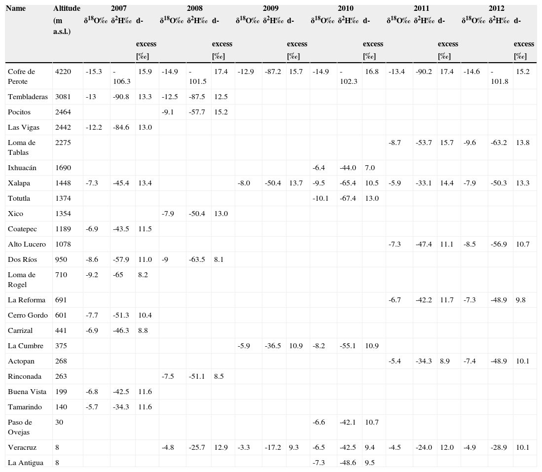
Results and discussionTable 1 shows the isotopic results of the meteoric water samples collected during 2007-2012. δ18O ranges from - 3.3 ‰ to −15.3 ‰ and δD from −17.2 ‰ to −106.3‰.
Stable isotope ratios δ18O‰ and δD‰ vs V-SMOW of accumulated rainfall in the upwind Sierra Madre Oriental study area, during the rainy seasons from 2007 through 2012.
| Name | Altitude | 2007 | 2008 | 2009 | 2010 | 2011 | 2012 | ||||||||||||
|---|---|---|---|---|---|---|---|---|---|---|---|---|---|---|---|---|---|---|---|
| (m a.s.l.) | δ18O‰ | δ2H‰ | d- | δ18O‰ | δ2H‰ | d- | δ18O‰ | δ2H‰ | d- | δ18O‰ | δ2H‰ | d- | δ18O‰ | δ2H‰ | d- | δ18O‰ | δ2H‰ | d- | |
| excess | excess | excess | excess | excess | excess | ||||||||||||||
| [‰] | [‰] | [‰] | [‰] | [‰] | [‰] | ||||||||||||||
| Cofre de Perote | 4220 | -15.3 | -106.3 | 15.9 | -14.9 | -101.5 | 17.4 | -12.9 | -87.2 | 15.7 | -14.9 | -102.3 | 16.8 | -13.4 | -90.2 | 17.4 | -14.6 | -101.8 | 15.2 |
| Tembladeras | 3081 | -13 | -90.8 | 13.3 | -12.5 | -87.5 | 12.5 | ||||||||||||
| Pocitos | 2464 | -9.1 | -57.7 | 15.2 | |||||||||||||||
| Las Vigas | 2442 | -12.2 | -84.6 | 13.0 | |||||||||||||||
| Loma de Tablas | 2275 | -8.7 | -53.7 | 15.7 | -9.6 | -63.2 | 13.8 | ||||||||||||
| Ixhuacán | 1690 | -6.4 | -44.0 | 7.0 | |||||||||||||||
| Xalapa | 1448 | -7.3 | -45.4 | 13.4 | -8.0 | -50.4 | 13.7 | -9.5 | -65.4 | 10.5 | -5.9 | -33.1 | 14.4 | -7.9 | -50.3 | 13.3 | |||
| Totutla | 1374 | -10.1 | -67.4 | 13.0 | |||||||||||||||
| Xico | 1354 | -7.9 | -50.4 | 13.0 | |||||||||||||||
| Coatepec | 1189 | -6.9 | -43.5 | 11.5 | |||||||||||||||
| Alto Lucero | 1078 | -7.3 | -47.4 | 11.1 | -8.5 | -56.9 | 10.7 | ||||||||||||
| Dos Ríos | 950 | -8.6 | -57.9 | 11.0 | -9 | -63.5 | 8.1 | ||||||||||||
| Loma de Rogel | 710 | -9.2 | -65 | 8.2 | |||||||||||||||
| La Reforma | 691 | -6.7 | -42.2 | 11.7 | -7.3 | -48.9 | 9.8 | ||||||||||||
| Cerro Gordo | 601 | -7.7 | -51.3 | 10.4 | |||||||||||||||
| Carrizal | 441 | -6.9 | -46.3 | 8.8 | |||||||||||||||
| La Cumbre | 375 | -5.9 | -36.5 | 10.9 | -8.2 | -55.1 | 10.9 | ||||||||||||
| Actopan | 268 | -5.4 | -34.3 | 8.9 | -7.4 | -48.9 | 10.1 | ||||||||||||
| Rinconada | 263 | -7.5 | -51.1 | 8.5 | |||||||||||||||
| Buena Vista | 199 | -6.8 | -42.5 | 11.6 | |||||||||||||||
| Tamarindo | 140 | -5.7 | -34.3 | 11.6 | |||||||||||||||
| Paso de Ovejas | 30 | -6.6 | -42.1 | 10.7 | |||||||||||||||
| Veracruz | 8 | -4.8 | -25.7 | 12.9 | -3.3 | -17.2 | 9.3 | -6.5 | -42.5 | 9.4 | -4.5 | -24.0 | 12.0 | -4.9 | -28.9 | 10.1 | |||
| La Antigua | 8 | -7.3 | -48.6 | 9.5 |
Both isotopic ranges are large compared to the respective analytical uncertainties, ± 0.1 ‰ for δ18O and ± 1.3 ‰ for δD. The isotopic pairs of δ18O‰ and δ2H‰ ranged from -3.3‰ and -17.2‰ at the Port of Veracruz (8 masl) in the rainy season of 2009 to -15.3‰ and -106.3‰ at Cofre de Perote (4200 masl) in the rainy season of 2007. These values are consistent with 2008-2010 precipitation data for Veracruz reported by Goldsmith et al. (2011). The deuterium excess values ranges between 7.0‰ and 17.4‰; the highest dex value was recorded at Cofre de Perote, indicating the largest separation from the LMWL.
Figure 4 shows the isotopic results for the study area, compared with the Global Meteoric Water Line, GMWL (Craig, 1961). Applying a linear regression on these results, the Local Meteoric Water Line (LMWL) for the upwind Sierra Madre Oriental study area is described by the equation δD= 7.44 δ18O + 7.3. The deuterium excess for the more isotopically depleted samples can be seen by their slight divergence from the GMWL. This LMWL is similar to δD = 7.42 δ18O + 7.9 for the Port of Veracruz (GNIP, 2014) but differs from another reported for the Coatepec area, also in the State of Veracruz, of δD = 8.21 δ18O + 18.5 (Goldsmith; 2011). Our LMWL for the upwind Sierra Madre Oriental study area also differs from those reported for other parts of Mexico: δD = 7.46 δ18O + 8.9 for the Colima Volcano area in the Mexican Pacific (Hartsough et al., 2008); δD = 8 δ18O + 11 for the central highlands of Mexico (based on data collected during the same years as for the Port of Veracruz; Cortes et al., 1997); and δD = 7.7 δ18O + 10.8 for the Transmexican Volcanic Belt (which is almost identical to theGMWL). These different LMLs show how the stable isotopic composition of precipitation is strongly influenced by local climatic conditions.
 for the upwind Sierra Madre Oriental study area, compared with the Global Meteoric Line (GML).")
The vertical isotopic gradient of precipitation along transect A-A’ (figure 1) of the study area was determined least squares linear regression of δ18O versus altitude for meteoric water samples collected during 2007-2012, yielding the relation δ18O = -2.1*Z (km) - 5.56‰; r2 = 0.87 (Figure 5a). The same vertical gradient was also found for precipitation in the Central Mexican Plateau (Durazo, 2008; Cortés and Durazo, 2001), but with a smaller y intercept value -3.26‰. A similar vertical isotopic gradient was calculated for deuterium: δD = -15.3*Z (km) - 34.5; r2 = 0.83. In addition, an abrupt enrichment in δ18Oand δD occurs at altitudes between 1,000 to 1,400 meters in the study area.This is may becaused by local topographic condition and/or an isotopic shift caused by tropical storms. But because this anomaly is located in an area with frequent fog, it may instead be caused by condensation processes under equilibrium isotope exchange (Gonfiantini et al., 2001). A third possible cause is plant evapotranspiration which, in tropical areas, may form mists and clouds that are isotopically depleted.
 δ18O‰ and (b) δD during the rainy season.")
The temporal isotopic variation at 3 sites located at different altitudes (Veracruz, Xalapa and Cofre de Perote) shows that during years characterized by heavy rainfall, the isotope composition is lighter (figure 6). This is particularly evident during 2010, the wettest year of the 6 year study due to a large number of storms in the Atlantic Ocean (five hurricanes, 13 tropical storms and one tropical depression; CONAGUA, 2012). This correlation between precipitation and isotopic depletion may be caused by cloud formation higher in the atmosphere during larger storms (Dansgaard, 1964).
Concluding Remarks
The stable isotope composition of rainy season precipitation has been characterized for the windward (Atlantic) side of the Sierra Madre Oriental, located on eastern flank of the Mexican Volcanic Belt in the State of Veracruz. The cumulative rainfall during the rainy season from May to October accounts for over the 80% of the total annual rainfall in the study area. Average isotopic values were measured in 44 cumulative precipitation samples collected during the rainy seasons of 2007 through 2012 collected at altitudes ranging from 8 to 4220 masl. The results are comparable with previously reported annual weighted averages for the Port of Veracruz (GNIP, 2012), supporting the methodology of focusing only on sample collection during the rainy season. A local meteoric water line of δD= 7.44 δ18O + 7.3 was determined from these isotopic results. In addition, calculated vertical isotopic gradients for δ18O and δD are - 2.1 ‰ km-1 and - 15.3 ‰ km-1 respectively. These gradients are consistent with previously reported gradients in Veracruz and at similar latitudes elsewhere in central Mexico. A mid-altitude isotopic anomaly near Xalapa, however, indicates that this isotopic gradient may cause an under estimation or over estimation of the calculated altitude of precipitation in particular cases, depending on local orographic precipitation and/or extreme weather conditions. The results of this study can be utilized to improve the understanding of groundwater recharge processes. In particular, this information can be used to evaluate the source altitude of precipitation recharging aquifers in this part of eastern Mexico.
The authors thank the Professors Pedro Morales Puente and Edith Cienfuegos Alvarado for providing high quality isotope data and comments on the scope of this research. We also thank the Professor Jaime Durazo Lozano, who before his retirement provided important feedback to help consolidate this work. Also, thanks to the Professors Adalberto Tejeda Martínez and Agustín Pérez Sesma of the Licenciatura en Ciencias Atmosféricas of the Universidad Veracruzana for their constructive comments. Special thanks to all the students and people from different communities who participated in the placement and sampling of precipitationcollectors.