


En el oriente de Sonora, México, se encuen-tran bien preservadas en rocas del Cretácico Superior de la región de Arivechi, estructuras de deformación compleja asociadas a movi-mientos verticales y actividad gravitacional como deslizamientos. Estas estructuras nos permitieron hacer la distinción entre estruc-turas de origen sin-sedimentario y de origen tectónico. Las rocas en Arivechi, de acuerdo con su litología y grado de deformación, se dividieron en dos unidades la Unidad Cañada de Tarachi (la más antigua) y la Unidad El Potrero Grande. La secuencia volcano-sedimentaria del Cretácico Superior tiene más de 6km de espesor y consiste en una secuencia de toba riolítica, andesita, conglomerado, arenisca, limolita y lutita que fueron depositadas en la cuenca tras arco de Arivechi. Dentro de la Unidad Cañada de Tarachi se encontraron monolitos y bloques que son los que constituyen uno de los objetivos principales de esta investigación. La edad de los monolitos y bloques incluyen rocas del Proterozoico, Paleozoico y Mesozoico. Los monolitos del Proterozoico están dominados por arenisca de cuarzo y dolomía. Los monolitos del Paleozoico y Mesozoico consisten en caliza y lutita interestratificadas, conglomerado y roca ígnea. Dos de los bloques graníticos fue-ron fechados; uno de ellos en 76 Ma (edad U/Pb en zircón) y el segundo en 70 Ma (40Ar/39Ar roca total por calentamiento a pasos). Los monolitos sedimentarios muestran una transición gradacional desde capas coherentes en sus porciones superior y media, a una intensa deformación en sus bordes y bases. Las estructuras dentro de los megaclastos y bloques, así como las rocas que los rodean, se estudiaron a detalle, para reconstruir el origen y desarrollo estructural de los monolitos, bloques y rocas encajonantes. La nueva información estratigráfica y estructural nos permite inferir que la posible fuente de los monolitos y bloques fue una tierra positiva localizada hacia el oriente de Arivechi en el oeste de Chihuahua y oriente de Sonora, México, denominada la Plataforma de Aldama. Las estructuras identificadas consisten en pliegues y fallas normales. La vergencia de los pliegues sugiere que el depocentro estaba localizado hacia el oeste del área de estudio.
Se efectuó una reconstrucción de paleoesfuerzos con el fin de documentar la historia tectónica del margen oriental de la posible cuenca de tras-arco de Arivechi. Se utilizó el método de inversión de esfuerzos a partir de los datos de deslizamiento de las fallas aplicando el método right-dihedra mejorado, seguido por una optimización rotacional. El análisis estructural y la reconstrucción de esfuerzos muestran que la evolución cinemática Mesozoico-Cenozoico se caracterizó por ex-tensión. Este régimen continuó después del Cretácico y ha sido identificado en el Mioceno. La secuencia de rocas fue modificada por una deformación Cenozoica tipo Cuencas y Sierras, caracterizada por fallamiento normal durante el Mioceno, como sugiere la reconstrucción de los paleoesfuerzos. Este último evento fue el resultado del cambio del régimen tectónico, de subducción de la placa Farallón al régimen de fallamiento transcurrente que da inicio al sistema de fallas San Andres-Golfo de California durante el Mioceno. La cronología de eventos identificados sugiere que la dirección de extensión NE-SW y ENE-WSW fueron seguidos por extensión E-W y WNW-ESE. Esto indicaría que la secuencia del fallamiento fue de NE-SW a ENE-WSW y, por último, a WNW-ESE.
Complex deformational structures assigned to vertical movements, and gravitational activity, such as gliding, are well preserved in Upper Cretaceous rocks of the Arivechi region, Eastern Sonora, Mexico. These structures allow us to discriminate between synsedimentary and tectonic origins. The rocks at Arivechi have been divided into two units according to their lithology and degree of deformation, the Cañada de Tarachi (oldest) and El Potrero Grande units. The Upper Cretaceous volcano-sedimentary sequence is more than 6km thick and consists mainly of andesite, rhyolithic tuff, conglomerate sandstone, siltstone, and shale-type rocks that were deposited in the Arivechi back-arc basin. Within the Cañada de Tarachi Unit, monoliths and blocks were found; these include rocks dating from Proterozoic, Paleozoic and Mesozoic times. The Proterozoic monoliths are dominated by quartz sandstone and dolomite and the Paleozoic and Mesozoic monoliths consist of limestone, shale, limestone-shale-sandstone, conglomerate and igneous rocks. Two granitic monoliths have been dated, one at 76 Ma (U/Pb zircon date) and the other at 70 Ma (40Ar/39Ar whole rock step-heating). The sedimentary monoliths show gradational transitions from coherent beds to intense deformation along their edges and bases. The structure within the monoliths, blocks and surrounding host rocks was studied in detail. The new stratigraphic and structural data suggest that the monoliths and blocks may have originated at a positive land east of Arivechi, in western Chihuahua and eastern Sonora, Mexico, known as the Aldama Platform. The identified structures consist of folds and normal faults. Fold vergence suggests that the depocenter was located westward of the study area. A paleostress reconstruction documented the tectonic history of the eastern margin of the Arivechi back-arc basin. Stress inversion of fault slip data was achieved by an improved right-dihedra method followed by rotational optimization. The structural analysis and paleostress reconstructions showed that the Mesozoic-Cenozoic kinematic evolution was extensional and continued during Cretaceous times; it has also been identified in Miocene rocks. The rock sequence was modified by basin and range-type normal faulting, as suggested by our paleostress reconstruction. The last event is the result of the beginning of tectonic extension at the onset of the shift from a subduction regime toward a transform fault regime, i.e., from the subduction of the Fallaron plate to the San Andreas Gulf of California fault system during Miocene times. NE-SW and ENE-WSW extension was followed by E-W and WNW-ESE extension. The faulting sequence went from NE-SW to ENE-WSW and subsequently to WNW-ESE.
The active margin of western North America, which encompasses eastern Sonora, is characterized by the development of extensive and thick Upper Cretaceous rocks units (Figure 1). It has been generally accepted that Upper Cretaceous deformation in eastern Sonora is associated with the compressional Laramide orogeny, characterized by the fold and thrust belt in the western United States. However, new studies in north-eastern Sonora suggest that compressional structures are related to gravitational gliding rather than thrusting and folding by tectonic compression. Gliding tectonics is a mechanism whereby large masses of rocks move down a slope under gravity, producing folding and faulting of varying extent and complexity (Allaby and Allaby, 1999).
.")
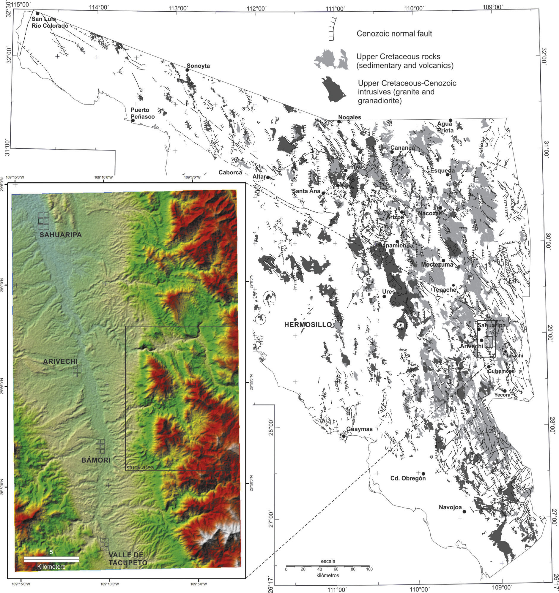
Location of the Arivechi region in eastern Sonora, Mexico and its relationship with the Upper Cretaceous rocks. Geologic information from the Servicio Geológico Mexicano (2008).
The Arivechi region was selected for better understanding of the evolution of these structures in eastern Sonora. Previous studies have reported that Upper Cretaceous rocks exist and that deformation is related to tectonic compression (Fernández-Aguirre and Almazán-Vázquez, 1991; Fernández-Aguirre et al., 1995; Minjárez-Sosa et al., 1985; Palafox et al., 1984; Palafox and Martínez, 1985). A detailed stratigraphic, morphostructural integration with structural analysis of fragile and ductile mesostructures present in the Upper Cretaceous rocks, paleostress analysis, and geochronological studies were conducted in order to ascertain whether the structures were originated by extension or compression.
Geological frameworkOur study area, located east of Arivechi, has been subjected to several studies of stratigraphy and paleontology and, to a lesser extent, structural geology. We defined two units of Mesozoic age: 1) Cañada de Tarachi Unit, and 2) El Potrero Grande Unit. A third unit is of Oligocene-Miocene age, the Sierra Madre Occidental volcanic sequence. The two Upper Cretaceous units constitute a volcano-sedimentary sequence of more than 6km thickness. El Potrero Grande Unit (the youngest Cretaceous sequence) consists of conglomerate, sandstone, siltstone, and shale with interbedded andesite and diorite dikes and layers of rhyolitic tuffs. These rocks constitude a column more than 2,400 m thick, but this is merly part of a thicker sequence. The oldest unite include a large number of unusually well-exposed megaclasts of different lithogies and ages. A megaclast is a term used in grain-size schemes after modification of the Udden-Wentworth sedimentary grain-size scale devised by Blair and McPherson (1999), who proposed a new fraction in sediment size to account for clasts larger than 4.1m. They proposed four sizes for the megaclast fraction: block (4.1 to 65.5 m), slab (65.5 to 1049 m), monolith (1 to 33.6km), and megalith (dI from 33.6 to 1075km). Megaclasts are associated to gravity sliding, or to vertical movements as described by various authors as olistoliths and olistostromes (Teale and Young, 1987; Heubeck, 1992).
Megaclasts have also been reported from numerous other tectonic environments; the Pyrenées (Johns et al., 1981), the Canadian Rockies (Cook et al., 1972), eastern Australia (Conaghan et al., 1976), the western US Cordillera (Heck and Speed, 1987), the Apennines (Naylor, 1982; Teale and Young, 1987), the Avalonían Terrane of New England (Bailey et al., 1989), Hispaniola (Heubeck, 1992), global recent continental slopes (Prior et al., 1982), Alaska (Harp et al., 2003), the Valles-San Luis Potosi Platform (Carrasco-Velázquez., 1977), and north-eastern Sonora (McKee and Anderson, 1998; McKee et al., 2005).
Megaclasts (monoliths and blocks) as described by Blair and McPherson (1999), have been found and are common in eastern Sonora Upper Cretaceous sequences (McKee and Anderson, 1998; Rodríguez-Castañeda, 2002; and McKee et al., 2005). These megaclasts have been linked to the emergence of a positive land, possibly related to the Late Jurassic Aldama Platform (Ramirez and Acevedo, 1957; Monreal, 1996; Haenggi, 2002; Anderson and Nourse, 2005) (Figure 2). The Aldama Platform is defined as an emerged land oriented NW-SE in north-west Chihuahua and eastern Sonora. Its extension toward north-eastern Sonora could be the Cananea High (McKee, 1991; Rodríguez-Castañeda, 2002). The Aldama Platform is bounded by faults related to the platform uplift. Uplift has been suggested as a mechanism of megaclast generation. It has been attributed to different causes but mainly to extension by reactivation of old faults and early Cenozoic pluton emplacement (Rodríguez-Castañeda, 2002; Roldán-Quintana, 2002). Epiclastic, pyroclastic and reworked deposits have also been identified in the study area. Flows and pyroclastic rock falls, mass waste deposits and volcaniclastic turbidites are common in the sequence deposited in the Arivechi back-arc basin. Towards the top of the unit the finest sediments increase in proportion, marking the latest stage of the evolution of this type of basin (Spalletti, 2006).
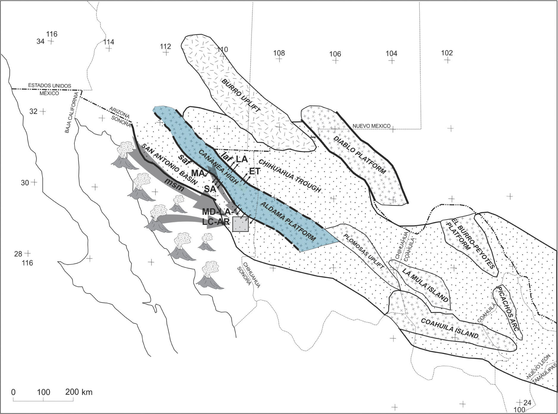
. Megaclast localities: Los Ajos (LA), El Tigre (ET), Magdalena (MA), San Antonio (SA), La Madera (MD), Lampazos (LA), Los Chinos (LC) and Arivechi (AR), msm = Mojave-Sonora megashear, saf = San Antonio fault, laf= Los Ajos fault. Modified from Anderson and Nourse (2005) including Monreal (1996).")
Map showing the paleogeography and structural elements that controlled the geologic evolution in the Upper Cretaceous. The Aldama Platform and its possible continuation towards the north-east of Sonora as the Cananea High were important elements in the evolution of the study area. The black arrows show the occurrence of slipped megaclasts and the gray arrows suggest the possible source of the sediments that constitute the rocky outcrops of the Upper Cretaceous in the study area (square). Megaclast localities: Los Ajos (LA), El Tigre (ET), Magdalena (MA), San Antonio (SA), La Madera (MD), Lampazos (LA), Los Chinos (LC) and Arivechi (AR), msm = Mojave-Sonora megashear, saf = San Antonio fault, laf= Los Ajos fault. Modified from Anderson and Nourse (2005) including Monreal (1996).
Although several studies have been carried out knowledge of Mesozoic geology in the Arivechi-Sahuaripa region is still sketchy. King (1939), Himanga (1977), Flinn (1977), Palafox and Martínez (1985), Minjarez et al. (1985), Pubellier (1987), and Fernández-Aguirre and Almazán-Vázquez (1991), among others, mainly focused on stratigraphic relationships; however, they also provide descriptions of structural.
Some of these descriptions are as follows: at Sierra El Chiltepín, 20km north-west of Arivechi, Himanga (1977) described a fold and a thrust with a NW-SE orientation as a result of a NE-SW compression. In the Cerro Macho area, west of Arivechi, Flinn (1977) reported the existence of an exotic Lower Cretaceous thrusting over Upper Cretaceous-Paleogene rocks. Stewart et al. (2002) described Proterozoic (700 Ma) sedimentary rocks at Sierra El Chiltepín consisting of well-cemented quartz sandstone intercalated with limestone containing stromatolites, which thrust eastward over Lower Cretaceous rocks.
Also, south of Sierra Chiltepín, at Cerros La Sata and El Mogallón, located 9km west of Arivechi, Almazán-Vázquez (1989) reported a package of Cambrian and Ordovician sedimentary rocks which are strongly dislocated by normal faults. He also reported outcrops of rocks of Jurassic and Cretaceous age similar to those exposed in the area of Arivechi.
On the other hand, in the Lampazos area, 40km north-east of Arivechi, Herrera and Bartolini (1993) and González-León (1988) reported Laramidic structures in Lower Cretaceous rocks which consisted of parallel folds with north-east vergence, NW-SE reverse faults and overthrust faults. Bartolini (1993) suggested that the Cretaceous rocks of the Lampazos area correspond to isolated platform fragments with no genetic connection with the sequences exposed in central and northern Sonora. He suggested that in eastern Sonora Lower Cretaceous blocks relate to parts of the Aldama Platform in central Chihuahua and that they slide westward along a NW-facing slope.
East of Arivechi, at Cerros Las Conchas and El Palmar, King (1939) observed that Paleozoic rock slivers could be found on top of Cretaceous rocks, and Palafox and Martínez (1985) and Fernández-Aguirre and Almazán-Vázquez (1991) noted that the deformation of the Laramide Orogeny in the area of Arivechi is represented by tight folds, thrusts and small reverse faults. Minjarez-Sosa et al. (1985) believe the folds and reverse faults are the result of the Albian-Cenomanian deformation, as reported by Rangin (1977, 1982).
Likewise, Pubellier (1987) reported the presence of four deformational events in the Sahuaripa and Arivechi region: a Jurassic event responsible for the deposit of coarse clasts; a tectonic phase assigned to the Late Albian-Late Santonian that carried rock fragments of Proterozoic basement on top of Lower Cretaceous rocks with transport N-NE; the Laramide orogeny in the Paleocene, which folded the structures of the previous event with a south-westerly vergence trend which in turn were cut by intrusive rocks during the lower Eocene, and, finally, two extensional events expanding from the Miocene to the present, creating normal faulting.
In the Lampazos area, north of Sahuaripa, the Cretaceous sequence may be lithologically correlated with western Chihuahua Lower Cretaceous rocks (Monreal, 1995). The Cretaceous rocks exposed in Lampazos and Sierra Los Chinos represent basin facies, whereas Lower Cretaceous rock facies, in Sonora, are platform facies (Monreal and Longoria, 2000). According to González-León (1988), there are differences between the facies of these rocks and the Bisbee group; the rocks of Lampazos rather resemble rocks of the same age as those of Chihuahua.
Lastly, at Sierra Los Chinos, 30km north of Sahuaripa, Monreal and Longoria (2000) and Díaz and Monreal (2008) concluded from the microfossil content that this area encompasses Lower Cretaceous rocks that correspond to the Chihuahua basin or to gradational facies between this basin and the Bisbee Basin.
MethodologyFor better understanding and constraining of the sequence of geological events in the Arivechi region, geological mapping was conducted at a scale of 1:25,000. We also aimed to complete stratigraphic measurements and descriptions of the lithology; measure and analyze the structural data obtained in the field; obtain paleostress tensors; construct the kinematics and paleostress evolution of the Arivechi area; determine the structural effects in the basin evolution; and discuss the implications of our results regarding the tectonic evolution of eastern Sonora. U/Pb zircon and 40Ar/39Ar geochronology was conducted for two selected rock samples.
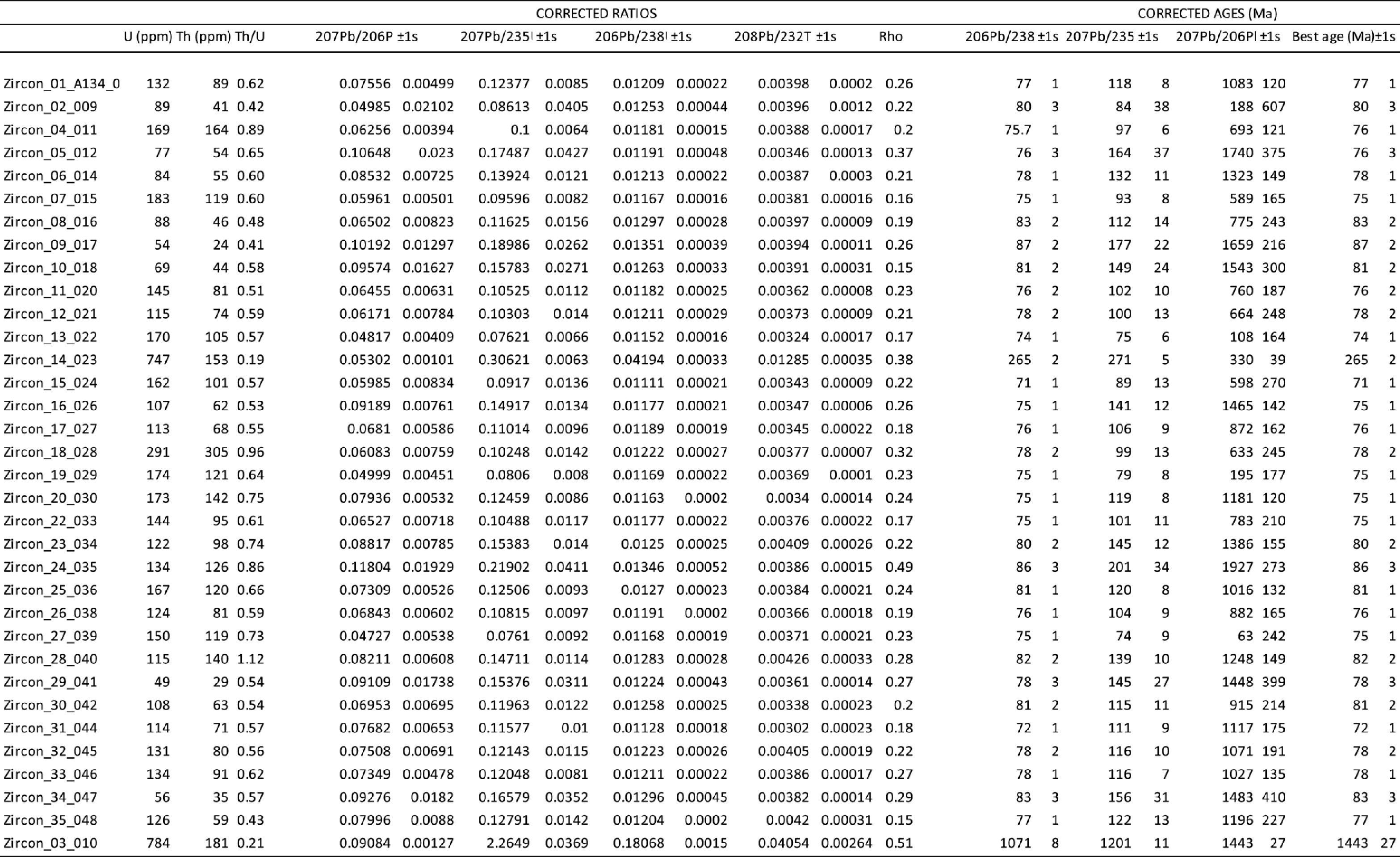
U/Pb MethodThe geochronology was carried out at the Centro de Geociencias Isotopic lab, UNAM. The method of dating is as follows. Laser ablation inductively-coupled plasma mass spectrometry (LA-ICPMS) U-Pb analyses were performed at the Laboratorio de Estudios Isotópicos (LEI), Centro de Geociencias, UNAM, employing a 193nm excimer laser workstation (Resolution M-050) coupled with a Thermo X-ii quadrupole ICPMS. The protocol reported by Solari et al. (2010) was used, employing a 23μm analytical spot and the Plešovice zircon (Slama et al., 2008) as bracketing standard. Time-resolved analyses were then reduced off-line with in-house developed software written in R (Solari and Tanner, 2011), and the output was then imported into Excel, where the concordia as well as age-error calculations were obtained with Isoplot v. 3.70 (Ludwig, 2008).
During the analytical sessions in which the data presented in this paper were measured, the observed uncertainties (1sigma relative standard deviation) on the 206Pb/238U, 207Pb/206Pb and 208Pb/232Th ratios measured on the Plešovice standard zircon were 0.75, 1.1 and 0.95% respectively. These errors were quadratically added to the quoted uncertainties observed on the measured isotopic ratios of the unknown zircons. This last factor takes into account the heterogeneities of the natural standard zircons. Provided that the isotope 204Pb, used to correct for initial common Pb, was not measured (because its tiny signal is swamped by the 204Hg normally present in the He carrier gas), the common Pb was thus evaluated with the 207Pb/206Pb ratio, and all the analyses carefully graphed on Tera and Wasserburg (1972) diagrams. Correction, if needed, was then performed with the algebraic method of Andersen (2002). In figures, tables and results 206Pb/238U ages are used for zircons < 1.0 Ga, whereas 207Pb/206Pb ages are cited for older grains. The TuffZirc algorithm of Ludwig and Mundil (2002) was used to calculate the best mean of 206Pb/238U ages, which is preferred for estimating the apparent age of those young zircons in which the 207Pb signal is low and thus yields imprecise results. The 207Pb/206Pb ages were furthermore considered as minimum ages because of the effect of possible Pb loss. We sampled granitic megaclasts in the Cañada de Tarachi Unit.
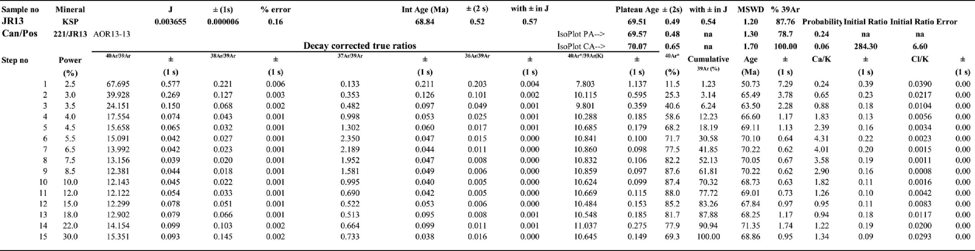
40Ar/39Ar MethodA K-feldspar mineral separation from a selected rock sample was carried out by standard methods at the mineral separation laboratory at the Estación Regional del Noreste, Instituto de Geología, UNAM. Age analyses were carried out at Queen's University 40Ar/39Ar geochronology laboratory, Kingston, Canada. For each mineral separate, ∼5–10mg samples of material were wrapped in Al-foil and stacked vertically into Al canisters, which were then irradiated in the McMaster University Nuclear Reactor in Hamilton, Canada, with a 40Ar/39Ar flux monitor Hb3gr hornblende (1072 ± 11 Ma [2σ]; Roddick, 1983). Following irradiation, the samples and monitors were placed in small pits, ∼2mm in diameter, drilled in a Cu sample holder. The holders were placed inside a small, bakeable, stainless steel chamber with a Zn Se viewport connected to an ultra-high vacuum purification system. Monitors were fused in a single step; with a focused New Wave MIR-10 30W CO2 laser. For the step heating experiments, the laser beam was focused at different temperatures on mineral separates or whole rock samples in approximately 10 steps. The evolved gases were purified with an SAES C50 getter for ∼5min. Argon isotopes were measured with a MAP 216 mass spectrometer, with a Bäur Signer source and an electron multiplier. All data were corrected for blanks, atmospheric contamination, and neutron-induced interferences (Roddick, 1983; Onstott and Peacock, 1987). All errors are reported as ±2σ, unless otherwise noted, and dates were calculated using the decay constants recommended by Steiger and Jäger (1977).
Paleostress analysisThe stress inversion method was applied with Win_Tensor software (Delvaux, 1993). The inversion is based on the assumption that slip planes occur in the direction of the maximum resolved shear stress. The slip direction at a fault surface is inferred from the striations’ slip-fiber lineations as a product of friction. Also, we determined the type of fault (normal or strike-slip) using drag folds that allowed us to discriminate faulting. Therefore, the strike and dip of the fault surfaces, the orientation of the lineation (pitch) and the sense of movement identified at the fault surface were the data used for the inversion.
The obtained fault slip data were used to compute the four parameters of the reduced stress tensor according to Angelier (1994): the principal stress axes were S1 (maximum compression), S2 (intermediate compression) and S3 (minimum compression), and the ratio of principal stress differences is R = (S2– S3) / (S1– S3). The four parameters were determined by successive use of an improved version of the right dihedral method of Angelier and Mechler (1977) and a four-dimensional numeric rotational optimization using the Tensor computer program of Delvaux (1993).
Local GeologyIn the study area two units of Upper Cretaceous age have been defined: 1) Cañada de Tarachi Unit, and 2) El Potrero Grande Unit and the Oligocene-Miocene Sierra Madre Occidental Cenozoic volcanic sequence (Figure 3).

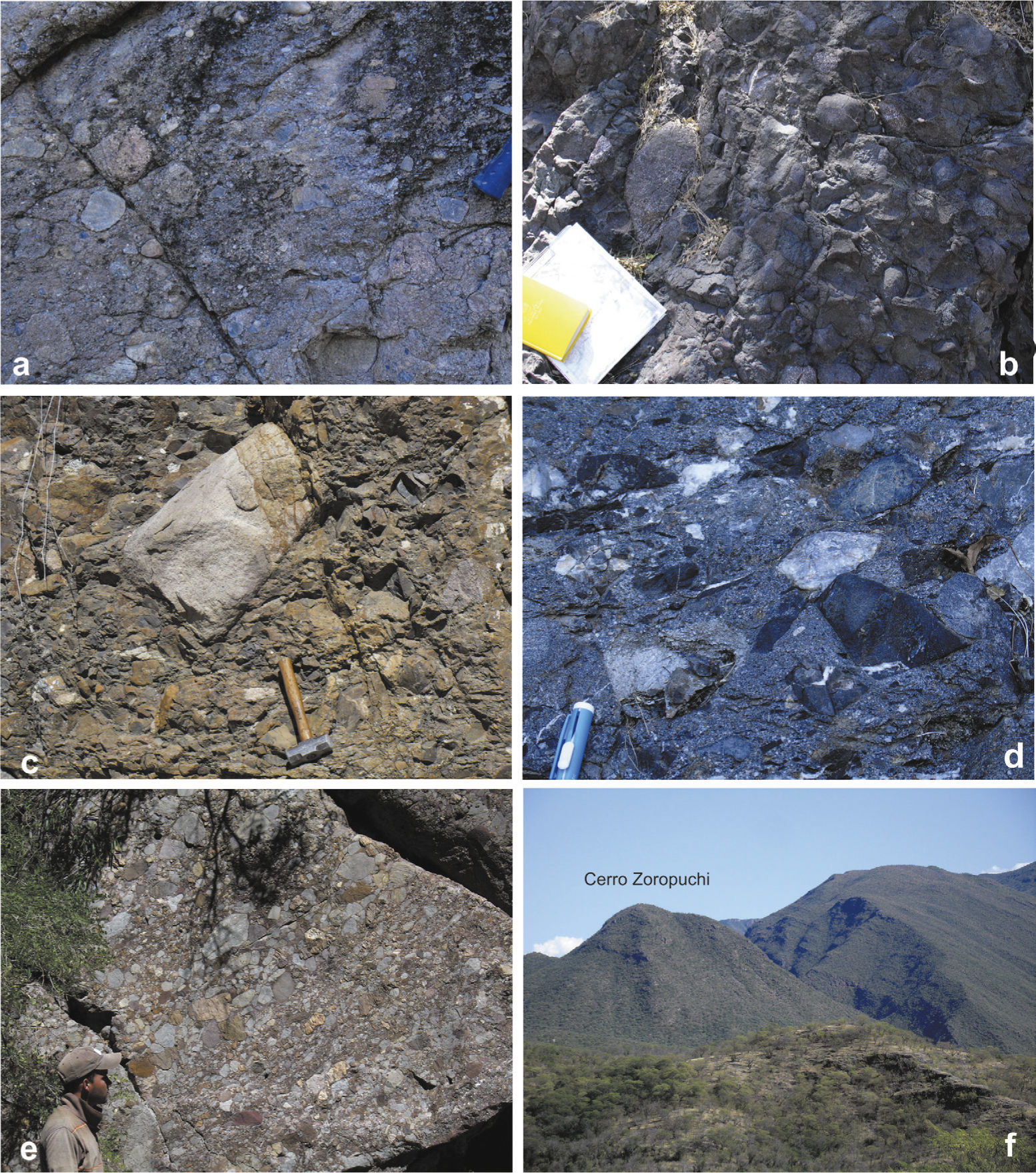
The oldest unit, known as the Cañada de Tarachi, a name taken from the arroyo of the same name, is located south-east of Arivechi (Figure 3).The Cañada de Tarachi Unit consists of a sequence of conglomerate, sandstone, siltstone, shale, and interbedded andesitic tuffs, with a significant presence of monoliths (Blair and McPherson, 1999) comprised of Precambrian, Paleozoic and Mesozoic sedimentary and igneous rocks. The conglomerate beds in the sequence are composed of several lithologies located at different levels; some of them form a package over 100 m, but most are metric in thickness (Figure 4). The conglomerates originated as a debris flow. Some of the conglomerates in the lower level are of volcanic origin and rounded shape, well sorted, with clast size ranging between 2 and 10cm, although a few of them measure 20cm (Figure 4a and 4b); the conglomerates derived from sedimentary rocks are generally angular in shape and unsorted (Figure 4c and 4d).The whole Cañada de Tarachi Unit, on the other hand, records a strong deformation, which is believed to be synsedimentary and related to the gravitational movements of the megaclasts caused by vertical uplift and sliding, rather than the result of a compressive tectonic deformation.
 and in the range to the right. Here, the conglomerate is entirely composed of both Paleozoic and Lower Cretaceous limestone rock rounded clasts.")
Conglomerate in Cañada de Tarachi Unit showing variation in composition and poor sorting. Images a and b show a conglomerate consisting of rock clasts derived from volcanic rocks which are more or less spherical in shape. Images c and d show a conglomerate consisting mainly of angular-shaped sedimentary clast rocks in a quartz-rich matrix. Images e and f show a conglomerate exposed to the north of the area in Cerro Zoropuchi (f) and in the range to the right. Here, the conglomerate is entirely composed of both Paleozoic and Lower Cretaceous limestone rock rounded clasts.
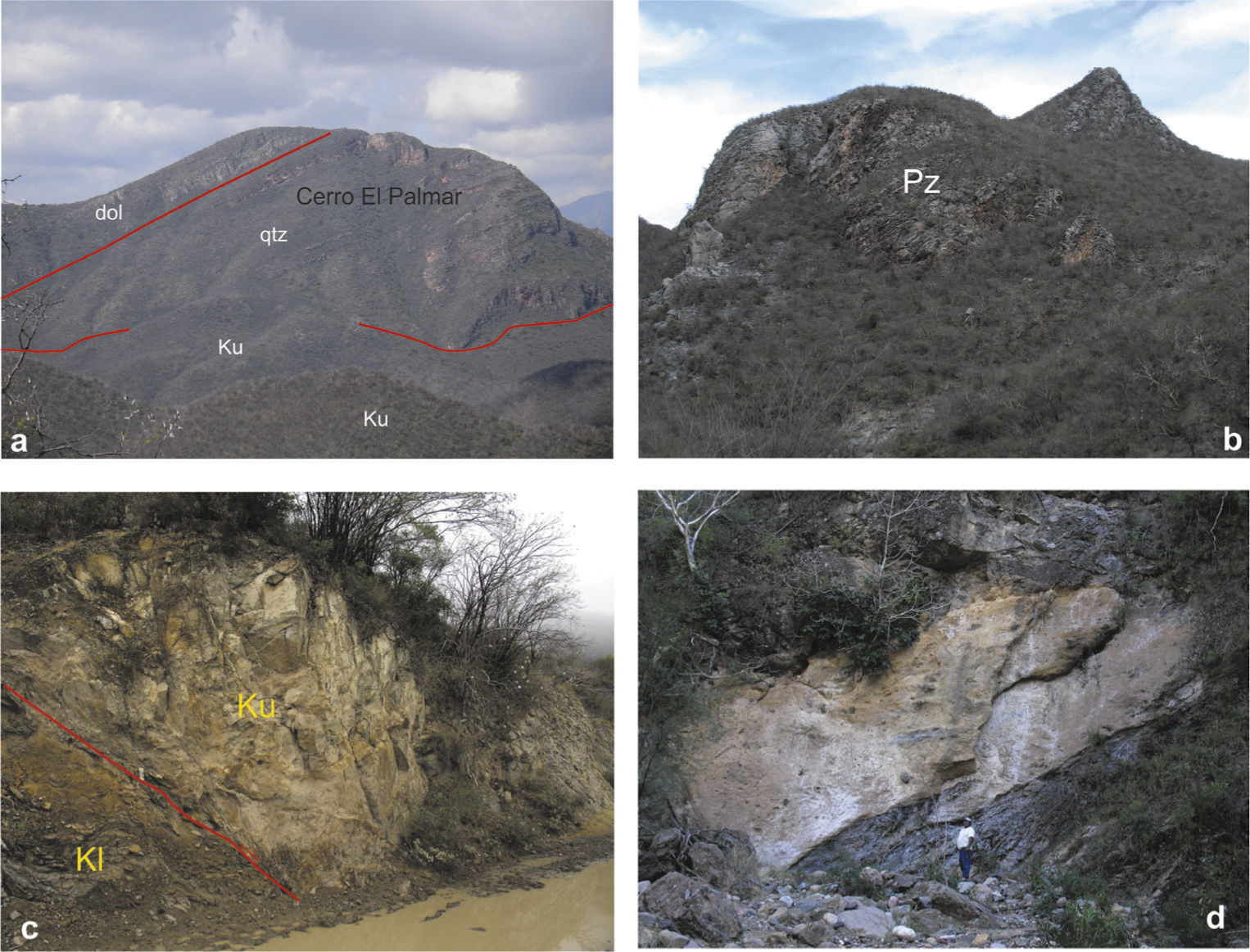
The Precambrian monolith is exposed at Cerro El Palmar (Figure 5a), south of arroyo Cañada de Tarachi. The monolith consists of layers of quartz sandstone and dolomite. It measures 7km long and 2km wide. The contact between rocks of the Neoproterozoic and the Cañada de Tarachi Unit are marked by a breccia over 10 m thick.
 megaclast composed of quartzite and dolomite of Proterozoic age constituting Cerro El Palmar. In the forefront is the conglomerate that, together with the megablock, forms part of the Cañada de Tarachi Unit. dol = dolomite, qtz = quartzite, Ku = volcano-sedimentary rocks. b) Paleozoic limestone megaclast. North view. c) 76 Ma granite block (Ku) which is jammed in Lower Cretaceous rocks (Kl). Note the deformation in the rocks of the Lower Cretaceous (Ki). d) Megaclast of uncertain age embedded in the Cañada de Tarachi Unit. Outcrop along the arroyo Cañada de Tarachi.")
Megaclasts exposed in the Arivechi region. a) megaclast composed of quartzite and dolomite of Proterozoic age constituting Cerro El Palmar. In the forefront is the conglomerate that, together with the megablock, forms part of the Cañada de Tarachi Unit. dol = dolomite, qtz = quartzite, Ku = volcano-sedimentary rocks. b) Paleozoic limestone megaclast. North view. c) 76 Ma granite block (Ku) which is jammed in Lower Cretaceous rocks (Kl). Note the deformation in the rocks of the Lower Cretaceous (Ki). d) Megaclast of uncertain age embedded in the Cañada de Tarachi Unit. Outcrop along the arroyo Cañada de Tarachi.
At the base of the monolith, near the contact with the Upper Cretaceous rocks, along the arroyo San Miguel an important finding was the presence of stromatolite fossils, possibly of the Jacutophyton genus, similar to those found in the Caborca region (Weber et al., 1979) assigned to the Neoproterozoic. The monoliths of Paleozoic rocks (Figure 5b) are 2km long, and consist of fossiliferous limestone and quartz sandstone which are assigned to the Mississippian by their fossil contents (Fernández-Aguirre and Almazán-Vazquez, 1991). These megablocks can be observed at Cerro Peñasco Blanco and Cerro Las Conchas.
At Cerro Las Conchas, another monolith composed of limestone, shale and sandstone and containing fossils from the Early Cretaceous (Fernández-Aguirre and Almazán-Vazquez, 1991) (Figure 3) is exposed. Bartolini (1993) suggested that these megaclasts have better correlation with exposed units in western Chihuahua than with rocks of the same age cropping out in Sonora.
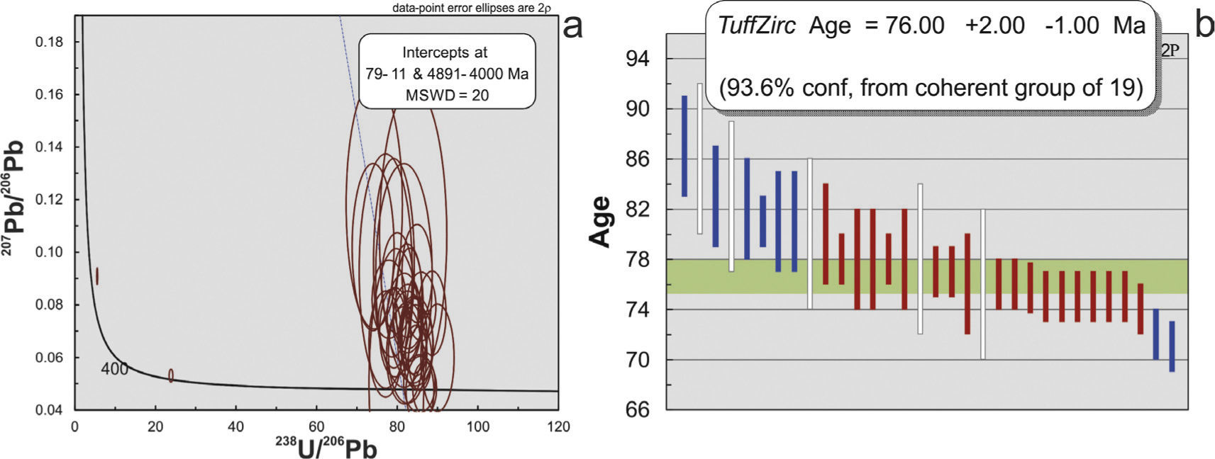
We found several megaclasts composed of granite, and from these we selected two for dating. One was collected in the arroyo Cañada de Tarachi and was dated by U/Pb zircon geochronology at 76.00 ± 2 Ma (Campanian, Late Cretaceous, Figure 6a and6b, Table 1), and a second sample around 100 m distant was collected at the Arivechi-Tarachi road and dated by 40Ar/39Ar step-heating of a k-spar at 69.57 ± 0.48 Ma (Figure 6c, Table 2). It was noted that these megaclasts are not only found on top but also within the sequence, in smaller thicknesses of dozens of meters. The fact that these are glided fragments, and because of their size were not previously identified as megaclasts, was the main reason for assuming that the stratigraphy was complicated and incorrectly interpreted by previous authors. Hence, we consider that the exposures of Cerro Las Conchas and the Paleozoic limestones are actually gliding megaclasts that are not “in situ.”
 Concordia curve for the A134-12 sample and b) Weighted mean age graph at 76 Ma.c) Ar/Ar data from the Arivechi-Tarachi road.")


No fossils have been identified in the Cañada de Tarachi Unit, apart from those that are contained in the slipped blocks. This statement has genetic significance for the sedimentary environment. The absence of fossils could be interpreted as resulting from the development of these basins inland. In terms of the thickness of this unit, based on the conducted mapping and strike and slip directions, we estimated that it must have a minimum thickness of 2000 m.
Fossil studies carried out on the conglo-merate clasts indicate Paleozoic and Early Cretaceous ages; therefore the Cañada de Tarachi Unit is situated in the Upper Cretaceous sequence. The 76 Ma U/Pb zircon date for the granite block at the Cañada de Tarachi Unit was interpreted as the crystallization date and the 70 Ma 40Ar/39Ar date was interpreted as the cooling age, i.e., postdating a Late Cretaceous age and suggesting that the onset of erosion was probably present by that time.
The base of the Cañada de Tarachi Unit is not exposed, but from correlation with other localities it has been interpreted as an angular unconformity unit over older rocks; in addition, the upper contact with the El Potrero Grande Unit is transitional to a younger volcaniclastic sequence.
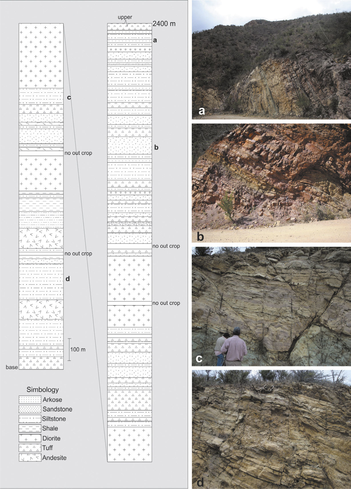
El Potrero Grande UnitThis unit takes its name from the ranch located south-east of Cerro El Batamote (Figure 3). King (1939) defines this as the Potrero For-mation, which seems to correspond to the same location, although he assigns it to the Albian. The El Potrero Grande Unit is much more of a volcano-sedimentary sequence than the Cañada de Tarachi Unit. The El Potrero Grande Unit consists of conglomerate, sandstone, siltstone, and shale with interbedded andesite, diorite strata dikes and layers of rhyolitic tuffs. These rocks together form a partial column more than 2,400 m thick (Figure 7). It must be said that we did not measure the entire El Potrero Grande Unit, because it is covered by Tertiary volcanic to the east.

A 2,400 m measured column on a segment of the El Potrero Grande Unit, from the Cerro El Volantín to the Cerro El Batamote. Pictures go from top to bottom, i.e., from a to d. The bold letters in the lithologic column show the approximate location of the picture in the column. Compare the structures observed in the El Potrero Grande Unit with structures recorded in the Cañada de Tarachi Unit in Figure 9.
The base of the unit consists of a section of conglomerates and volcanic rocks of andesitic composition that includes tuffs, continuing with shale, siltstone and sandstone that form a rhythmic sequence.
Isotopic K/Ar ages in biotite concentrates from volcanic rocks provided dates of 83.4 ± 4.17Ma (Pubellier, 1987), 84 and 86 Ma K-Ar, respectively, for two tuffs in the upper part of the sequence, indicating an Upper Cretaceous age for the sequence (Grajales-Nishimura et al., 1990). In the Sahuaripa-Natora road we dated a tuff in a similar section 20km north of the area. The age sample was dated as 76.3 ± 1.98 Ma (U/Pb zircon at Geociencias isotopic Lab), placing it in the Campanian (Upper Cretaceous). We consider this tuff equivalent in age to tuffs in our study area.
The Upper Cretaceous in Arivechi, eastern Sonora was deposited in a deep sedimentary basin that received sediments from an existing volcanic arc and also accumulated sediments from both the exposed north-western and north-eastern basement.
Structural GeologyThe structures found in the study area are normal and strike-slip faults, as well as mesoscopic folds. They are the result of two different processes recorded in the Upper Cretaceous units. The older mechanism is a Cretaceous gravitational gliding deformation, which affects only the Cañada de Tarachi Unit; the El Potrero Unit shows only extension and the associated structures.
Gliding tectonics is interpreted as a mechanism whereby large masses of rocks move down a slope under gravitational force, producing folding and faulting at different extents and complexity. The fine-grained rocks of the Cañada de Tarachi Unit are folded into smaller tight folds as seen along the arroyo Cañada de Tarachi. The structures are considered synsedimentary in order to denote their inferred formational environment, and include extensional faulting and reverse faults and folds.
In northern Sonora, Rodriguez-Castañeda (2002) interpreted a similar sequence formed by gravitational re-sedimentation generated by tectonic activity along the south-west margin of the Cananea High, a positive land that could be the continuation of the Aldama Platform into Sonora.
The extensional faults are observed along the two units whereas contractional structures are restricted to the thin bedded sandstone and siltstone exposed in the front of the sliding mass observed in the Cañada de Tarachi Unit.
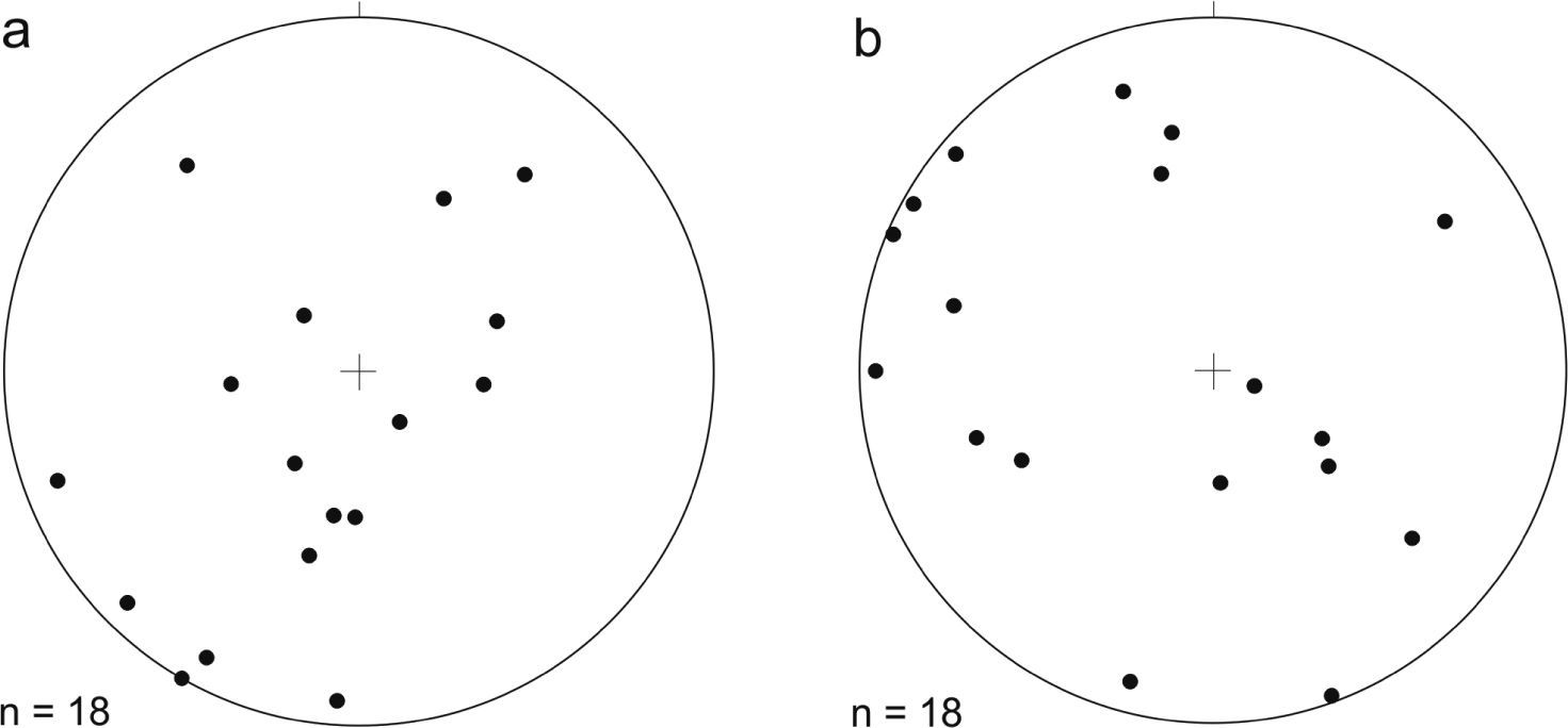
Fold data collected from the Cañada de Tarachi Unit indicate that folds are asymmetric and related to detachment surfaces. The fold vergence (Figure 8) suggests that the sequence was transported towards the south-west and to a lesser extent towards the north-east. Figure 9 corresponds to “Z” fold kinematic indicators, showing vergence towards the south-west. In Figure 9a the layer that serves as detachment for the formation of folds has a 019 strike with a 30NW dip. Most of the folds display axial surfaces oriented NW-SE and plunging to the north-east with two arrays, one with an average of 83° and the second with an average of 34°.
 Poles of axial surfaces showing south-west vergence. b) Fold hinge lines showing a horizontal to sub-vertical plunge oriented NW-SE.")
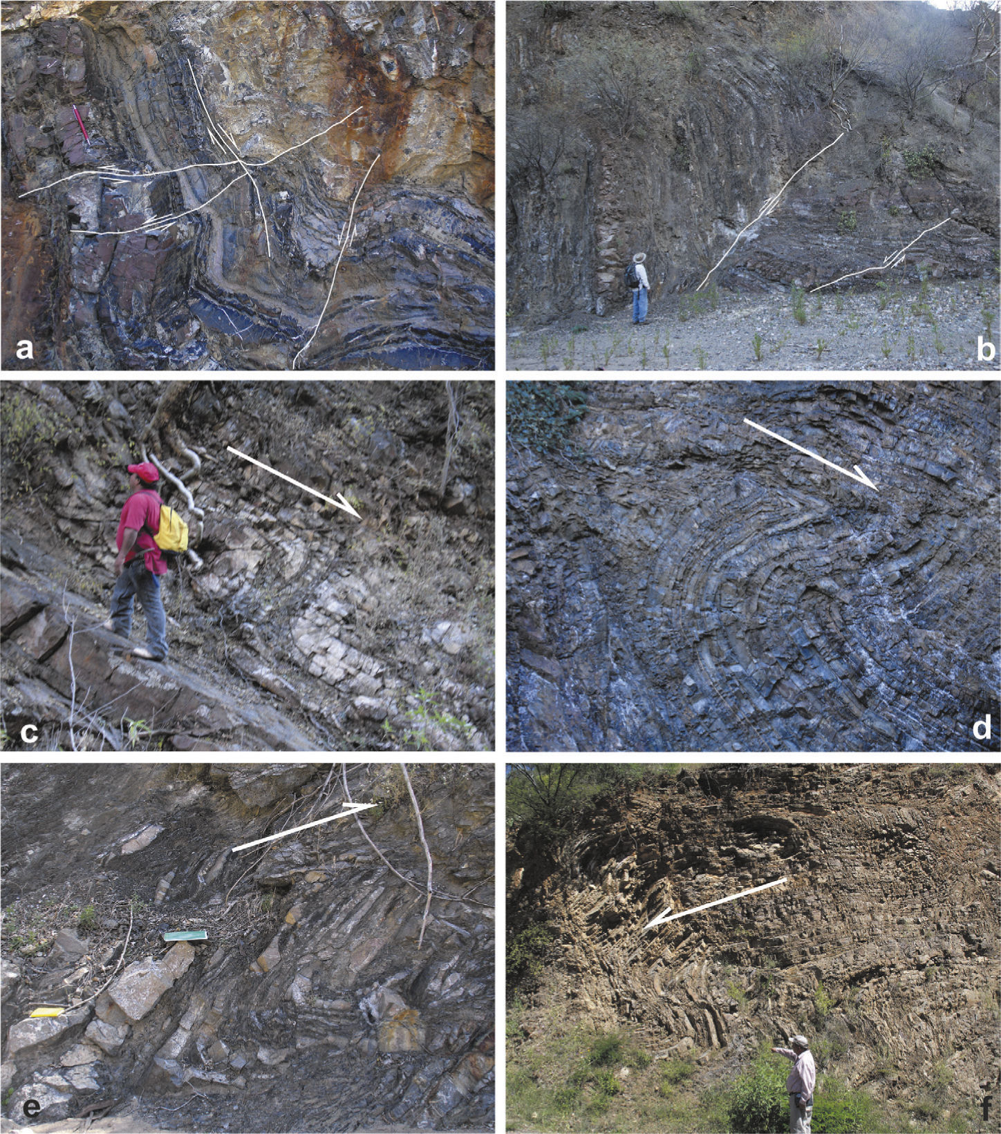
 recorded in the base of the Cañada de Tarachi Unit. Note the scale of deformation. Reverse and normal faults plus folds affect the sequence. Z folds recorded in the Cañada de Tarachi Unit (c, e, d) suggest transport to the south-west. In a, the bed where the man stand is the base of the detachment. The S fold on f crops out along the Arivechi-Tarachi road, also suggesting transport to the west.")
Intense deformation (a and b) recorded in the base of the Cañada de Tarachi Unit. Note the scale of deformation. Reverse and normal faults plus folds affect the sequence. Z folds recorded in the Cañada de Tarachi Unit (c, e, d) suggest transport to the south-west. In a, the bed where the man stand is the base of the detachment. The S fold on f crops out along the Arivechi-Tarachi road, also suggesting transport to the west.
The folds show no obvious genetic relationship to tectonic contraction within the megaclasts. It is clear that folds are related to a synsedimentary deformation corresponding to the emplacement of the megaclast as indicated by its geometry and location.
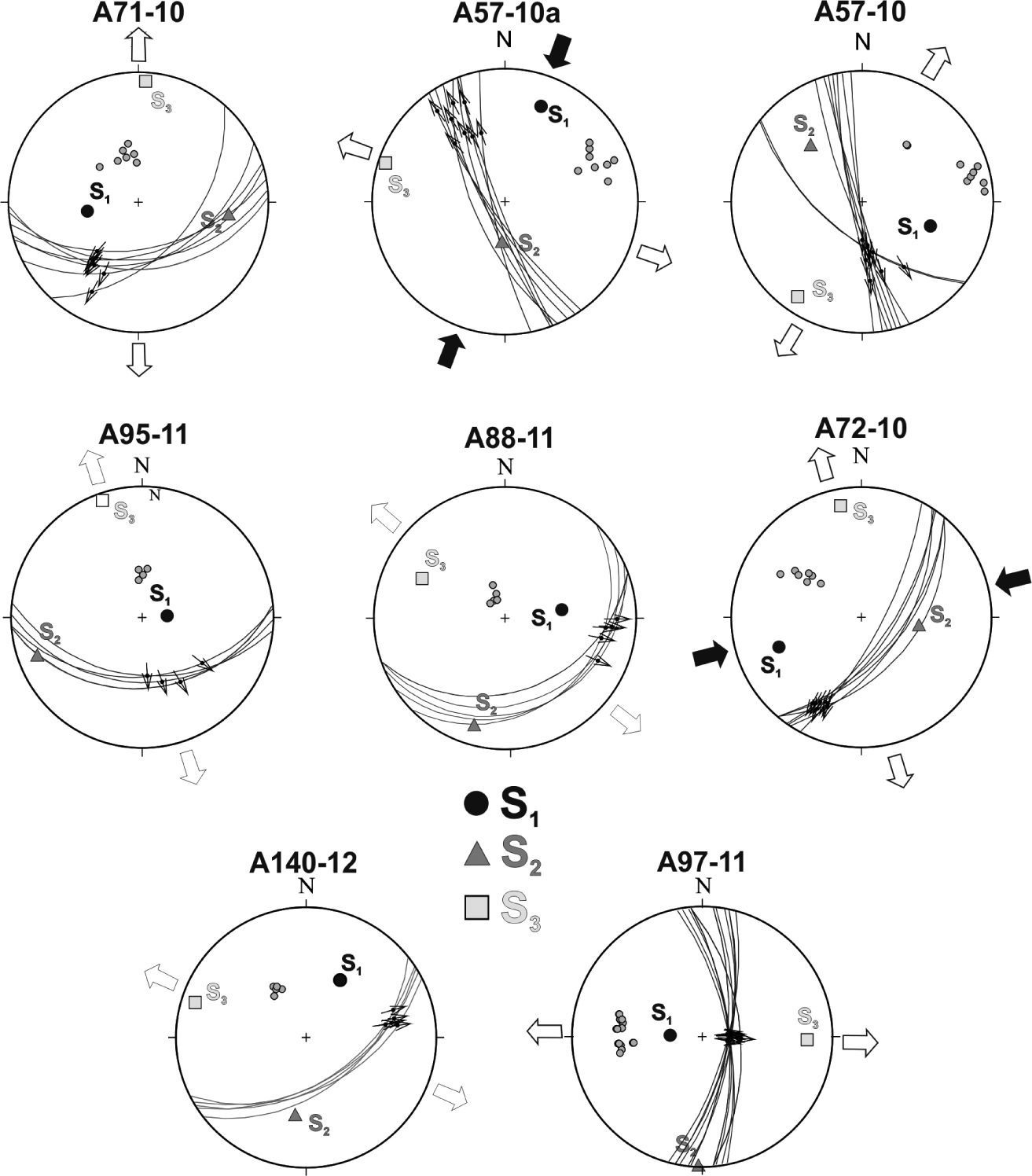
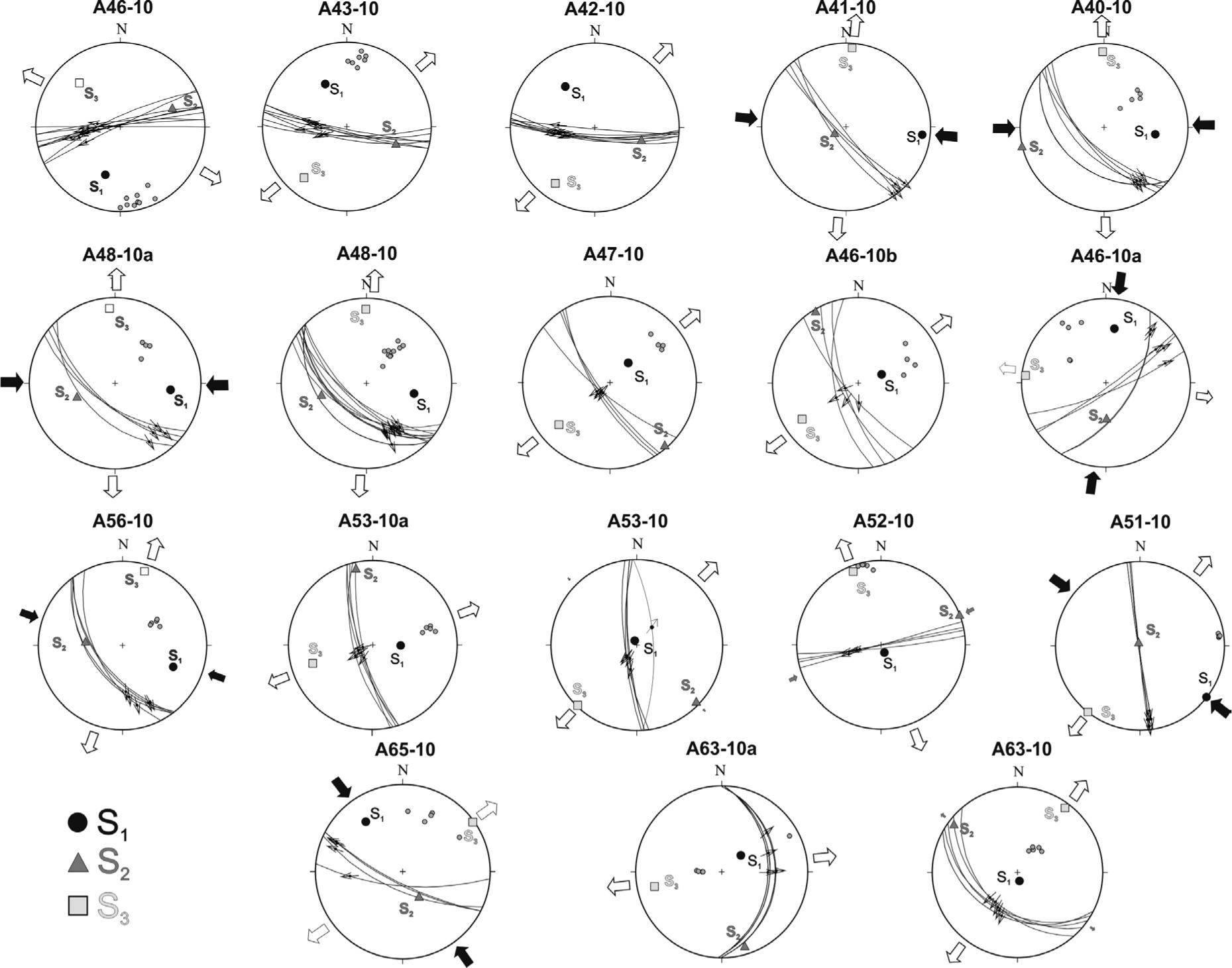
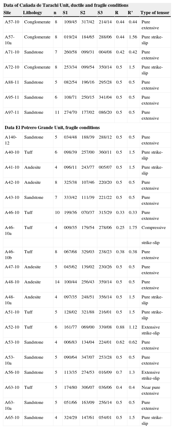
Normal faulting and paleostress reconstructionTo explain the tectonic processes from which the development of these structures originated, a paleostress field reconstruction is offered. The paleostress analysis was performed with measured surface data collected over faults in the Upper Cretaceous rocks along the Arivechi-Tarachi road, in the section between Cerro Las Conchas and Cerro El Volantín and along the arroyo Cañada de Tarachi. The data sites are located in sedimentary rocks as much as in igneous rocks. The displacement over the measured faults is generally from centimeters up to meters, and the faults are normal, although some of them record a strike-slip component. In general, all the measured faults display good striations. The results obtained from the paleostress analysis are in shown in Table 3 and in Figures 10 and 11.
Parameters of the paleostress tensors calculated for rocks of the Upper Cretaceous.
| Data of Cañada de Tarachi Unit, ductile and fragile conditions | ||||||||
|---|---|---|---|---|---|---|---|---|
| Site | Lithology | n | S1 | S2 | S3 | R | R’ | Type of tensor |
| A57-10 | Conglomerate | 8 | 109/45 | 317/42 | 214/14 | 0.44 | 0.44 | Pure extensive |
| A57-10a | Conglomerate | 8 | 019/24 | 184/65 | 288/06 | 0.44 | 1.56 | Pure strike-slip |
| A71-10 | Sandstone | 7 | 260/58 | 099/31 | 004/08 | 0.42 | 0.42 | Pure extensive |
| A72-10 | Conglomerate | 8 | 253/34 | 099/54 | 350/14 | 0.5 | 1.5 | Pure strike-slip |
| A88-11 | Sandstone | 5 | 082/54 | 196/16 | 295/28 | 0.5 | 0.5 | Pure extensive |
| A95-11 | Sandstone | 6 | 108/71 | 250/15 | 341/04 | 0.5 | 0.5 | Pure extensive |
| A97-11 | Sandstone | 11 | 274/70 | 177/02 | 086/20 | 0.5 | 0.5 | Pure extensive |
| Data El Potrero Grande Unit, fragile conditions | ||||||||
| A140-12 | Sandstone | 5 | 034/48 | 188/39 | 288/12 | 0.5 | 0.5 | Pure extensive |
| A40-10 | Tuff | 6 | 098/39 | 257/00 | 360/11 | 0.5 | 1.5 | Pure strike-slip |
| A41-10 | Andesite | 4 | 096/11 | 243/77 | 005/07 | 0.5 | 1.5 | Pure strike-slip |
| A42-10 | Andesite | 8 | 325/38 | 107/46 | 220/20 | 0.5 | 0.5 | Pure extensive |
| A43-10 | Sandstone | 7 | 333/42 | 111/39 | 221/22 | 0.5 | 0.5 | Pure extensive |
| A46-10 | Tuff | 10 | 199/36 | 070/37 | 315/29 | 0.33 | 0.33 | Pure extensive |
| A46-10a | Tuff | 4 | 009/35 | 179/54 | 278/06 | 0.25 | 1.75 | Compressive |
| strike-slip | ||||||||
| A46-10b | Tuff | 8 | 067/68 | 329/03 | 238/23 | 0.38 | 0.38 | Pure extensive |
| A47-10 | Andesite | 5 | 045/62 | 139/02 | 230/26 | 0.5 | 0.5 | Pure extensive |
| A48-10 | Andesite | 14 | 100/44 | 256/43 | 359/14 | 0.5 | 0.5 | Pure extensive |
| A48-10a | Andesite | 4 | 097/35 | 248/51 | 356/14 | 0.5 | 1.5 | Pure strike-slip |
| A51-10 | Tuff | 5 | 128/02 | 321/88 | 216/01 | 0.5 | 1.5 | Pure strike-slip |
| A52-10 | Tuff | 6 | 161/77 | 069/00 | 339/08 | 0.88 | 1.12 | Extensive strike-slip |
| A53-10 | Sandstone | 4 | 006/83 | 134/04 | 224/01 | 0.62 | 0.62 | Pure extensive |
| A53-10a | Sandstone | 5 | 090/64 | 347/07 | 253/28 | 0.5 | 0.5 | Pure extensive |
| A56-10 | Sandstone | 5 | 113/35 | 274/53 | 016/09 | 0.7 | 1.3 | Extensive strike-slip |
| A63-10 | Tuff | 5 | 174/80 | 306/07 | 036/06 | 0.4 | 0.4 | Near pure extensive |
| A63-10a | Sandstone | 5 | 051/66 | 163/09 | 256/14 | 0.5 | 0.5 | Pure extensive |
| A65-10 | Sandstone | 4 | 324/29 | 147/61 | 054/01 | 0.5 | 1.5 | Pure strike-slip |
n= number of fault data used for stress tensor determination; s1, s2, s3 = plunge and azimuth of principal stress axes; R = stress ratio (s2 – s3)/(s1 – s3), R¿ = tensor type index.


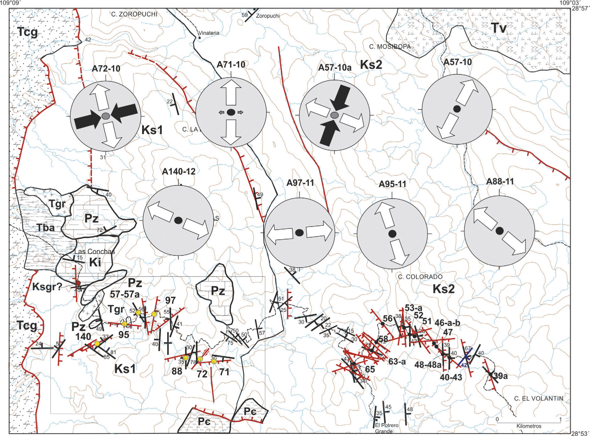
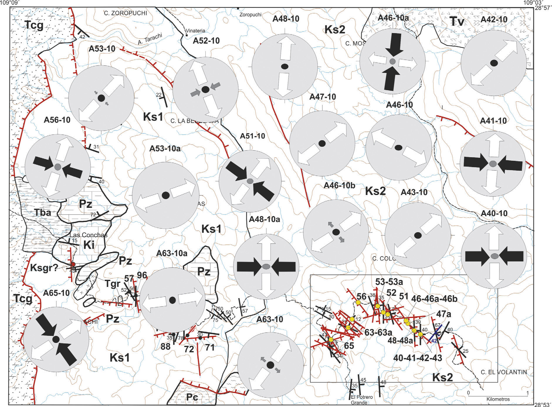
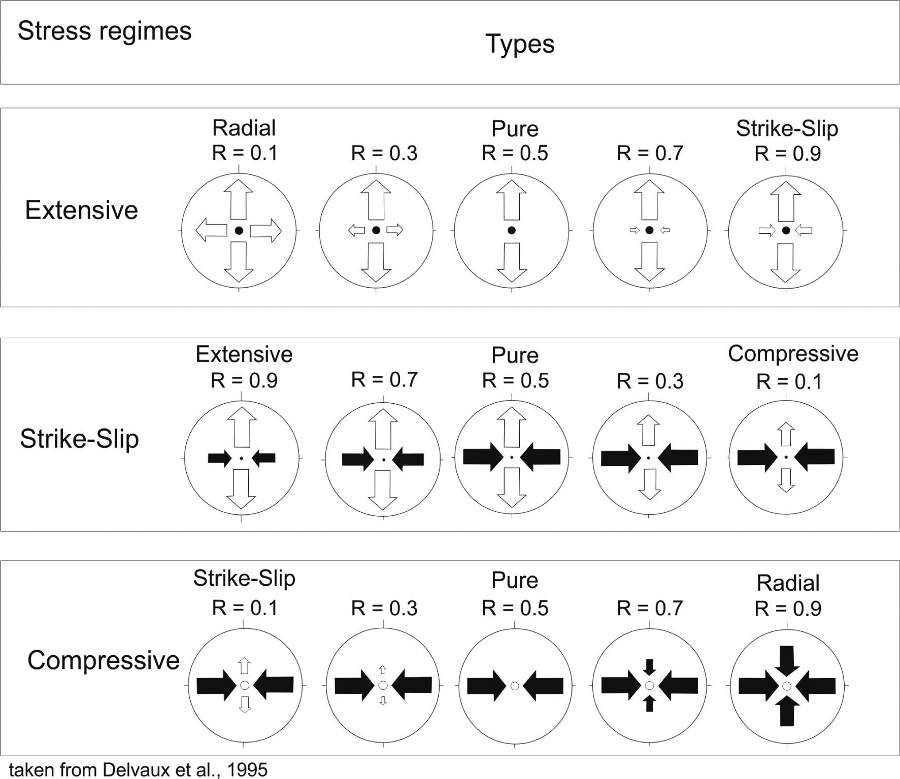
The evolution of the stress fields is shown in structural maps (Figures 12 and 13) with symbols indicating the two horizontal SHmax and Shmin, with black inward arrows for compressive stress and white outward arrows for extensive stress. The length depends on the magnitude of the relative stress in function of the stress relation R and orientation of the principal stress directions. The vertical axis is indicated by an open circle for a compressive regime (vertical extension), by a dot for a strike-slip regime, and by a black circle for an extensive regime (vertical compression). The classifications proposed by Delvaux et al. (1995) for the stress tensors are: radial / pure / strike-slip extensive, extensive / pure / compressive strike-slip or strike slip / pure / radial compressive based on the relative magnitude of the intermediate axis and given by the stress relation R (Figure 14).


, a dot for strike-slip regimes (S2 vertical) or an empty circle for compressive regimes (S3 vertical).")
Types of stress regimes and their representation on a map. Arrows indicate the azimuth of horizontal stress axes, with their length according to relative stress magnitude, in base of the stress ratio R. White outward arrows indicate extensive stress axes and black inward arrows compressive stress axes. Vertical stress axes are symbolized by a solid circle for extensive regimes (S1 vertical), a dot for strike-slip regimes (S2 vertical) or an empty circle for compressive regimes (S3 vertical).
The orientation of the stress field was determined with the measured structures which show a clear sense of movement. Twenty-six sites were examined in the studied sector. The sites are located in outcrops of Upper Cretaceous rocks. The results of the inversion (Table 3) and their correlation allow the definition of several paleostress groups. The tensors are grouped according to their similarity, based on the direction of the main axes SHmax, Shmi, the stress regime index and the stratigraphic relation.
The faulted sediments, which belong to the Cañada de Tarachi Unit, dip towards the north-east. Almost all the faults are normal with oblique-slip motions predominating, but dip-slip and strike-slip are present and play an important role. Faults in Figure 13 show that the motion of these faults was induced by extension along a direction of S3 NW-SE, NE-SW and E-W for dip-slip normal faults; whereas S1 is in general NNE-WSW and ENE-WSW in relation to strike-slip faults (Figure 10).
On the other hand, at the El Potrero Grande Unit faults are dip-slip, oblique slip normal faults and strike-slip faults. The direction of S3 is NE-SW for dip-slip normal faults; NE-SW, almost N-S, and NW-SE for the oblique normal faults, and the S1 directions E-W, NW-SE, and WNW-ESW are related to strike-slip faults (Figure 11).
EvolutionThe studies carried out in the area indicated the existence of two Cretaceous sequences differentiated by their composition and stratigraphic position. The observed structures are mesoscopic folds in the Cañada de Tarachi Unit and the development of normal faults and smaller proportion by strike-slip faults.
The Cañada de Tarachi Unit is characterized by intercalations of conglomerate, sandstone, siltstone, rhyolitic tuff and andesite, showing a strong deformation. The geographic extension of Precambrian, Paleozoic and Lower Cretaceous monoliths or remnant rocks suggests that they belong to a basement possibly located towards the east, in the State of Chihuahua. The fold vergence (Figure 8) indicates that the sequence was transported towards the south-west.
The directions of stress that we were able to determine from the Cañada de Tarachi Unit from normal oblique, normal dip-slip and strike-slip faulting are shown in Figures 10 and 12. Local results are given in Figure 12 for both minimum horizontal stress (S3) and maximum stress (S1). Extension stress (S3) is more common than compression stress (S1), because the normal faults (subverticalS1) in the section are common whereas strike-slip faults moved when both compression and extension were horizontal (subverticalS2). Normal faults with different orientations, such as NNW-SSE, NE-SW, E-W, and N-S, show high and medium dips (Figure 10). The faults with an oblique component in the NNW direction have high dips towards the west and were induced by the S3 extension direction NE-SW; NE oblique faults have medium angle dips towards the south-east and are the result of a N-S and NW-SW S3; E-W dip-normal faults dip towards the south with intermediate angles, whereas the N-S faults display high angle dips towards the east as a result of NNW S3 and E-W S3 directions, respectively (Figure 10).The strike-slip faults with NE-SW and NW-SE orientations characteristically have high angle dips associated with ENE-WSW and NNE-SSW compression (S1), respectively (Figure 10).
The paleostress tensors are shown in Table 3 and in the structural planes of Figures 12 and 13. The tensors were grouped according to their similarities based on the stress regime and the direction of the stress axis. The paleostress is only recorded in Upper Cretaceous rocks, the reason why chronological ordering of paleostress data depends upon rock comparison with other sites outside the study area.
The Cañada de Tarachi Unit is characterized by an extension regime and, to a lesser degree, by a pure strike-slip regime (Figure 13). The main axis of extension (S3) is almost horizontal with a NW-SE main direction, and with a smaller proportion in a NE-SW direction. The main axis of compression, corresponding to the strike-slip movements,(S1) is sub-vertical with a NE-SW direction. In conclusion, the previous analysis shows that at the time there was an extension regime with development of high angle normal faults.
Interpretation of the paleostress results in the El Potrero Grande Unit indicates a stress regime characterized by extension and strike-slip regimes, both well defined (Figure 13). The extension regime displays an S3 closer to the horizontal in a NE-SW direction (Figure 13). The strike-slip regime is shown by a varying main axis of compression S1, almost horizontal in sites A41-10 and A51-10, sub-vertical in sites A40-10, A46-10a, A41-10, A48-10a, A56-10 and A65-10, and with almost E-W, NW-SE and N-S directions in site A46-10a. The stress of extension S3 is horizontal to a N-S, NE-SW direction (Figure 13).
DiscussionsThe megaclasts identified in the study area range in age from the Proterozoic to the Mesozoic. Two megaclasts of granitic composition were dated, one by U/Pb date on zircon and one by 40Ar/39Ar step-heating date on K-spar, since they were less than 100 m apart, we assume that they were from the same pluton and therefore we can interpret the dates as concordant. One is an emplacement aged 76.0 ± 2.0 Ma by U/Pb zircon geochronology, and the second one gives a K-spar cooling age of 69.57 ± 0.48 Ma according to 40Ar/39Ar step-heating geochronology. It is assumed that the megaclasts are part of the same pluton and were deposited at the same time as part of a debris flow in an alluvial slope. The ages of the granitic blocks suggest that the minimum age for the onset of the erosion is not earlier than 76 Ma according to the U/Pb date. The difference in zircon U/Pb and K-feldspars 40Ar/39Ar concordant dates (76 Ma and 70 Ma, respectively) suggest rapid uplift and erosion. As a consequence of these processes, rapid uplift and erosion, the column of Cretaceous sediments is more than 10km thick. The absence of fossils and the rhytmitic sedimentation at the youngest unit suggests a neritic or a lacustrine continental environment.
From a tectonic perspective, it can be considered that the recognized megaclasts were formed in an extensional environment where topographic highs were formed, causing block gliding. Our hypothesis is that the Arivechi area was located near or at the edge of the Aldama Platform. It is probable that the Aldama Platform continues to north-east Sonora as the Cananea High.
Other places with similar relationships in eastern Sonora near the study area are: Sierra La Madera, Lampazos and Sierra Los Chinos. In north-east Sonora along the margins of the Cananea High megaclasts were also identified at Sierra Los Ajos and Rancho San Antonio as well as in central Sonora in the Magdalena, Santa Ana and Tuape areas.
In the Arivechi-Tarachi area, east of Arivechi, two stress regimes have been recognized, one of pure extension and another with strike-slip displacement, affecting both Upper Cretaceous units exposed in the study area.
Prior to this study no paleostress data were reported for the area, but now we are able to compare the paleostress data with information reported by Rodríguez-Castañeda (2002) for the Rancho San Antonio area in north-eastern Sonora, i.e., an andesitic dike that registered NE-SW (S3 = N058) and WNW-ESE (S3 = N283) extensions at the arroyo Las Minas. In another locality towards the south of the previous locality at Rancho El Babiso, on rocks of the Baucarit Formation, S3 is oriented NE-SW (Sh= 073). Other studies that can help with the interpretation of the Arivechi data include the method used by Angelier et al. (1981) in Baja, California Sur (around Santa Rosalia) and Angelier et al. (1985) at the Hoover Dam, Nevada, United States; they identify a chronology of events where the directions of a NE-SW to ENE-WSW extension are followed by an E-W to WNW-ESE extension with clockwise rotation. These studies suggest that such directions of extension are a product of a Basin and Range type normal faulting regime; even though it is possible to consider that the faults affecting the two Late Cretaceous units of the study area are associated with the Basin and Range event.
The faults with a strike slip to oblique component movement are associated with the extensional regime and not with a strike-slip phase of deformation. That means that the direction of extension was not always perpendicular to the strike of the faults. Alternatively, along either side of the mass there must be strike-slip accommodation of movement by faults, reflecting the surface outcrop of the detachment plane as a tear fault. Tectonic compression, sensu stricto, was not detected. The package that constitutes the Cañada de Tarachi Unit is molded by deformational gliding structures. The identified ductile structures are related to the gliding tectonics of the monoliths. Assuming that compression existed in the area as a result of the Laramide deformation, we should observe structures, such as folds, that indicate a transport movement towards the north-east. Instead, the observed folding indicates a vergence towards the west and south-west. However, El Potrero Grande does not display these characteristics, indicating a different evolution of the tectonic environment.
Therefore, the development of basins and volcanism in central Sonora during the Triassic (Stewart and Roldán, 1991) and, later, the development of volcanism and the opening of basins during the Early and Middle Jurassic (Anderson and Nourse, 2005) mark an evolution associated with extension in a possibly thinned and warmed lithosphere. The sedimentation in the Upper Jurassic-Lower Cretaceous and Upper Cretaceous occurred under an extension environment, and indicates the completion of the evolution of the Mesozoic basins that occurred before a period of stability and peneplanation in the Upper Cretaceous-Paleocene in north-west Sonora.
ConclusionsThe volcano-sedimentary rocks of the Upper Cretaceous in the Arivechi comprise a sequence with sediment thickness of more than 6km that was deposited in a back-arc basin. The stratigraphy of the Arivechi region consists of two Upper Cretaceous units: the Cañada de Tarachi Unit and the El Potrero Grande Unit. Both units show evidence of rapid denudation, magmatism and sedimentation developed in an extensional type regime environment.
An outstanding characteristic of the Cañada de Tarachi Unit is the presence of glided monoliths and blocks with tabular forms of diverse dimensions, from a few meters to several kilometers in length. Two of these megaclasts of granitic composition were dated: one at 76.0 ± 2.0 Ma by U/Pb zircon geochronology at the Cañada de Tarachi, and the second one at 69.57 ±0.48 Ma by 40Ar/39Ar step-heating of a K-spar along the Arivechi-Tarachi, road, interpreted as an emplacement and cooling age respectively, and a maximum age for the onset of erosion.
The recognized structures and the results of the paleostress study along with the stratigraphy demonstrate two periods of deformation. The first happened at the beginning of the Late Cretaceous, as shown by the presence of monoliths, blocks, and folds only in the Cañada de Tarachi Unit. The megaclasts were emplaced as slumps in soft sediments during successive mass movements derived from differential uplifts and associated gravitational gliding processes. Overall, the clasts deposited in the Arivechi basin are angular, unsorted monoliths, blocks and very coarse to fine slab. The back-arc Arivechi basin had to be a deep one, since a thick (6km) detritus accumulation derived from a magmatic arc and basement source rocks can be observed. The origin of these uplifts was the result of several vertical regional movements of the Aldama Platform, as indicated by megaclasts interbedded in the sequence at different stratigraphic levels. The mechanism that originated uplifts suggests earthquakes, e.g., M 8, which occurred along the Denali fault in Alaska (Harp et al., 2003), triggered the mass-sliding and generation of megaclasts.
The folds are associated with movements along a synthetic extensional detachment, linked to the evolution of the gliding masses. The contact between megaclasts and the basal Cretaceous rocks are pervasively sheared because of the downslope transport. At the front and along the base of the megaclasts disintegration and a complex deformation associated with simple shear can be observed. The transport direction to W-SW is deduced from the kinematics of folds recorded in the Cretaceous Cañada de Tarachi Unit. Contractional structures are not observed in the El Potrero Grande Unit. Folds in the El Potrero Grande Unit are associated with the evolution of faults such as drag folds.
The second event was characterized by normal and strike-slip faults, which can be seen in both units. Paleostress analysis in the Arivechi region indicated that the area has undergone radial to NE-SW to NW-SE extension, and local compression in an E-W and NW-SE direction. The chronology of events identified suggests that the directions of extension NE-SW and ENE-WSW were followed by an E-W and WNW-ESE extension. This would indicate that the sequence of faulting went from NE-SW to ENE-WSW and later to WNW-ESE.
The presence of strike-slip faults is the result of a dominant extensional tectonic regime. It is thought that strike-slip faults were formed as a response to a main E-W and NW-SE compression stress, as a result of the reactivation of normal faults oriented NE-SW. Perhaps this reactivation occurred in faults during the sliding of masses and reactivated during the transformation of the tectonic regime during Miocene-Pliocene times. The NE-SW to WNW-ESE extension was in general the cause of the tilting towards the north-east of the Upper Cretaceous layers.
The structural analysis and paleostress reconstruction of the Arivechi area allow recognition of two major deformation events that can be related (1) to the Farallon oceanic lithosphere subduction under the North American plate and the opening of the back-arc basin and (2) a stress field characterized by extension related to the right lateral displacement between the Farallon and North American plates. In both Late Cretaceous units only extension is observed. This extension can be divided into two periods. The first one, during Lower Cretaceous times, is recorded in the structures and megaclasts observed at the Cañada de Tarachi Unit. These structures are the result of differential uplifts which caused the gravitational gliding masses and contractional structures. The second one is related to the basin and range Cenozoic normal faulting observed in both units. No evidence of compressional tectonics is reported in this work.
The tectonic history of the Aldama Platform and the Cananea High is based upon their lithological constitution and structural heterogeneous basement, which are precursors of the faulting initiated at the end of the Early Cretaceous. Both structural elements were possibly active at least from the Jurassic (Aldama Platform) to the late Early Cretaceous in the light of the characteristics identified in the rocks involved in the sliding processes.
This research project was funded by a UNAM-PAPPIT Grant, number 22-IN103710. Grinding of samples and preparation of thin sections were performed by Pablo Peñaflor and Aime Orci, respectively, from the Estación Regional del Noroeste, Instituto de Geología, UNAM. U/Pb dating was completed at the Centro de Geociencias, UNAM, where Carlos Ortega-Obregón and Ofelia Pérez-Arvizu carried out the laboratory analysis. Identification of fossils in the conglomerate was performed by Rogelio Monreal from the Department of Geology of the University of Sonora at Hermosillo.